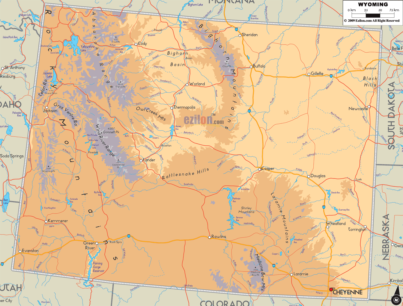

Description: The Physical map of Wyoming State, USA showing major geographical features such as rivers, lakes, topography and land formations.
 Introduction: Wyoming, a state in the heart of the Rocky Mountain West, beckons with its vast wilderness and dramatic landscapes. The state's vast geography, rich with an array of geological wonders, embodies the essence of the untamed American West. Wyoming's landscapes reflect nature's grandeur, with towering mountains, rolling plains, and snaking rivers presenting a picturesque vista.
The expansive Physical Map of Wyoming State captures the breathtaking majesty of these terrains, offering a comprehensive overview of the state's geographical spectrum. As we traverse from the southern tips to the northern edges and from the eastern plains to the western crags, we'll also explore the heart of Wyoming's central landscapes, immersing ourselves in a topographical journey that unveils the geographical narrative of this captivating state.
The southern region of Wyoming is a gateway to the state's contrasting landscapes. Here, the rugged contours of the Rocky Mountains extend into the horizon, weaving a scenic blend of rolling hills and towering peaks. The Snowy Range is an area of great importance within the Medicine Bow Mountains. Medicine Bow Peak stands as a testament to the captivating allure of the mountains.
Further east, the sprawling Laramie Plains stretch out, strikingly contrasting the mountainous skyline. The broad and level plains display a few minor hills and bodies of water that mirror the expanse above. The North Platte River, with its sparkling waters, carves through the plains and mountains alike, its course highlighted against the earthy tones of the landscape.
Venturing into the northern part of Wyoming is like stepping into a geographical marvel where the land rises to meet the sky in the form of the iconic Bighorn Mountains and the Absaroka Range. These mountain ranges, with their snow-capped peaks, tower over the landscape, creating a surreal vista.
The pristine Bighorn Lake, nestled amidst these ranges, mirrors the sky and the surrounding crags, enhancing the region's scenic charm. The Yellowstone River, originating from the heart of the Yellowstone National Park, meanders through the terrain, nurturing an array of ecosystems. The dense forests covering the hills show the different land features in the northern area. The verdant canopies of the trees contribute to the map's sense of depth.
As one transitions to the eastern part of Wyoming, the terrain unfolds into a blend of plains and hills, where the high plains meet the ancient Black Hills. The topography here presents a contrasting combination of the gentle hills and the vast plains stretching out to the horizon.
The Belle Fourche River flows through the land, making curvy paths across the flat areas and around the small mountains. It paints a picturesque portrayal of the region's topography. The Thunder Basin National Grassland is a hallmark of this area, its vast stretches of grasslands portraying the quintessential plains topography, with scattered patches of hills and water bodies providing a respite to the continuous period of tables.
The western region of Wyoming is a geographical treasure, where the majestic Tetons and the Wind River Range dominate the landscape. The famous Grand Teton and Gannett Peak stand majestically against the sky, revealing the stunning beauty of the Rocky Mountains in this location.
The pristine waters of Jackson Lake and Fremont Lake, cradled amidst these mountain ranges, reflect the azure skies and the surrounding peaks, creating scenic vistas that captivate the soul. With its winding course, the Snake River journeys through the mountains and valleys, its path carving through the landscape, creating a dynamic interaction between water and land.
The heart of Wyoming, with its central region, embodies a fusion of the state's diverse landscapes. Here, the Wind River Range extends its mountainous charm, its rocky contours juxtaposed against the vast expanses of plains. Casper Mountain, with its rugged silhouette, stands as a sentinel over the southern edge, its peak casting long shadows over the plains.
The North Platte River, continuing its journey from the southern region, meanders through the central plains, its waters nurturing the land. The central region's topography, a blend of mountains, rivers, and tables, encapsulates the essence of Wyoming's geographical diversity, each land formation narrating a tale of the state's natural heritage.
In conclusion, the Large Detailed Physical Map of Wyoming thoroughly explores the state's profound geographical diversity. It meticulously outlines the landscapes, from the mountainous realms to the sprawling plains and from the meandering rivers to the tranquil lakes, unveiling the natural tapestry that forms the state's geographical identity.
Through the lens of this map, one embarks on a vicarious journey across Wyoming's diverse terrains, over the mountains, through the plains, and along the rivers, encapsulating the scenic essence and the geographical grandeur of the Rocky Mountain West.
Introduction: Wyoming, the gem of the Rocky Mountain West, is home to many majestic geographical wonders. The state boasts an array of accessible roadways that serve as pathways to enchanting vistas. These roads facilitate transportation and offer an ever-evolving scenery of the state's rich topography, leading to riveting destinations of rivers, lakes, mountains, hills, and other distinct land formations. Let's traverse the key roadways that unveil the geological tapestry of Wyoming.
The southern region of Wyoming is a confluence of mountainous terrains and expansive plains. Interstate 80 (I-80) is the primary artery that traverses the southern part of the state, providing access to the mesmeric Medicine Bow National Forest and the Snowy Range Scenic Byway, leading to the lofty Medicine Bow Peak. Venturing onto Highway 230, travelers can find themselves amidst the serene banks of the North Platte River, a haven for fishing and riverside camping.
Northern Wyoming Access: In northern Wyoming, the majestic landscapes of the Bighorn Mountains and Yellowstone National Park are within reach via US Highway 14. This highway and its alternate routes 14A and 16 provide panoramic drives through the Bighorn National Forest, leading to the pristine Bighorn Lake. The iconic US Highway 20 is a gateway to Yellowstone, winding through picturesque landscapes alongside the Shoshone River, ultimately leading to the national park's East Entrance.
Exploring the hills and plains of eastern Wyoming becomes accessible by driving on I-90 and US Highway 85. These routes offer a journey through the historical Black Hills, with access to the tranquil waters of the Belle Fourche River. Venturing along State Route 59, travelers will find themselves amidst the expansive Thunder Basin National Grassland, a haven of unique topography and serene natural settings.
One can witness the stunning Tetons mountains and various landscapes in Grand Teton National Park by driving along the scenic routes of US Highway 89 and 191. These highways journey through the heart of the Jackson Hole Valley, providing astounding views of Jackson Lake and the towering Grand Teton. An alternative way to experience the awe-inspiring Wind River Range is to traverse the curving Snake River by traveling on US Highway 26.
The central region of Wyoming, adorned with a blend of rivers, mountains, and plains, is accessible through a network of roads. Interstate 25 (I-25) carves through the center, leading to the charming city of Casper, nestled against Casper Mountain. The North Platte River can be accessed along this route, offering many recreational opportunities. State Highway 220 leads to the historic trails of the Oregon, California, and Mormon Pioneer, each narrating tales of the region's rich heritage amidst a backdrop of varied topography.
The roadways of Wyoming provide a gateway to explore the essence of the Rocky Mountain West. The intertwining network of interstates, US highways, and state routes facilitates access to Wyoming's geographical marvels and narrates the state's unique geological narrative.
As one embarks on a road trip across this fascinating state, every turn reveals a new facet of Wyoming's diverse landscapes, offering an adventurous exploration into the heart of America's natural wonders.

Counties and Road Map of Wyoming
Counties and Road map and map image of Wyoming.

Regional Directory of Canada
Information and guide about Canada and website listing.

Regional Directory of United States of America
Information and guide about United States of America and websites with American topics.

Regional Directory of Europe
Information and guide about Europe and websites with European topics.

Regional Directory of Australia
Information and guide about Australia and websites with Australian topics.