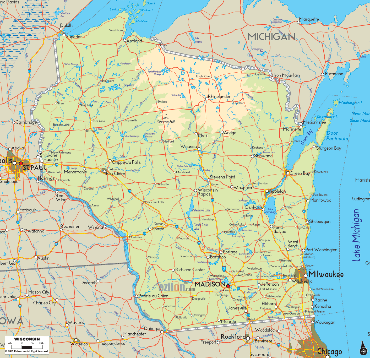

Description: The physical map of Wisconsin State, USA showing major geographical features such as rivers, lakes, topography and land formations.
 Introduction:
Wisconsin, a state with a rich and varied geographical profile, narrates a tale of ancient glacial movements, serenading rivers, expansive lakes, and undulating terrains through its Physical Map. The map serves as a testament to the state's diverse landscapes, visually exploring Wisconsin's physical characteristics, formed and reformed over millennia.
As you venture from the southern to the northern parts and from the eastern shoreline to the western boundaries, you see many natural formations that define, divide, and decorate the state's expansive geographical canvas.
Southern Wisconsin acts as a gateway to the state's varied topographical features. Though often overshadowed by the more dramatic landscapes of the North, the South holds its own with a display of flat plains gradually giving way to gentle rolling hills, a transition molded by the ancient glaciers.
The rivers in this region are tranquil yet persistent in their course. The Rock River meanders through, sketching a pathway highlighting the lush vegetation along its banks. The Fox River holds historical significance, being a part of the state's early industrial narrative.
Additionally, the Sugar River is excellent, especially during autumn. The riverbanks become a lively sight as numerous vibrant leaves adorn the surroundings. Though not as abundant as in the North, the lakes are nonetheless significant. Lake Koshkonong and Lake Geneva are cherished natural resources, with Lake Geneva, in particular, being a popular retreat offering a respite from urban life.
The topographical highlight of the region undeniably is the Driftless Area, an unglaciated section that boasts a unique and contrasting terrain. The area unfolds a rugged landscape filled with hills, ridges, and valleys, a sight to behold and explore.
The northern part of Wisconsin is a sanctuary of natural splendors. A haven for outdoor enthusiasts, this region is dotted with forests that stretch as far as the eye can see and lakes that mirror the sky.
The Northwoods exemplify the serene beauty of the North, with Vilas County being a notable mention for hosting over 1,300 glacial lakes amidst thick forests. Chippewa and St. Croix rivers are more than just water courses; they are lifelines that sustain the surrounding ecosystems.
Their calm waters reflect the dense woodland and the sky, creating a picturesque ambiance. On the far western part, the Gogebic Range rolls across the land with modest hills, while on the eastern part, the Penokee Range offers a rougher, more dramatic, hilly terrain. These ranges are the remnants of ancient mountains, whittled down over eons, yet still stand as prominent land formations today.
As one ventures toward eastern Wisconsin, the majestic presence of Lake Michigan becomes an unavoidable and mesmerizing sight. The lake, with its vast expanse, dictates the weather, the topography, and the region's lifestyle. The rivers, Milwaukee and Sheboygan, play crucial roles in connecting the land to the lake, serving ecological and economic purposes.
They traverse through cities and countryside before surrendering to the mighty Lake Michigan. The Kettle Moraine State Forest is a treasure trove of glacial landforms. Its kames, kettles, and eskers tell a tale of a glacial past, offering a visual narrative of the ice sheets that once covered the land. The forest allows individuals to engage in enjoyable activities while enhancing their knowledge of nature and the past.
The famous Mississippi River runs through the western part of Wisconsin. This natural boundary is crucial in facilitating transportation and driving business activities. The river's banks are a lesson in topography, with bluffs, cliffs, and slopes housing various vegetation and wildlife. The La Crosse River and Black River are not to be overlooked, each carving out a unique path and contributing to the region's geographical and ecological narrative.
One can delve into Wisconsin's glacial history in the Coulee Region. The deep valleys and steep ridges visually represent the erosional and depositional forces that shaped the land.
The central part of Wisconsin is a geographical nexus that blends the features of its neighboring regions. Here, one can appreciate the state's variety in a condensed form. The Wisconsin River, cutting through the heart of the state, is a vital waterway that showcases the harmonious coexistence of urban settlements and natural landscapes.
The river's journey is one of changing vistas, from dense forests to urban landscapes and back to serene woodlands. The Winnebago Pool Lakes, including Lake Winnebago, Lake Butte des Morts, and Lake Poygan, form a vital aquatic system, a haven for wildlife and human recreational activities.
The Central Plain, with its prairies, wetlands, and scattered woodlands, offers a gentler topographical contrast to the Driftless Area's rougher, more rugged terrains.
The Physical Map of Wisconsin guides understanding of the state's geographical composition. Wisconsin reveals its physical story through each river bend, lake shore, hill, and valley, a tale of a land sculpted by time, water, and ice. The map invites exploration, a journey across terrains that narrate the ancient and ongoing geological processes shaping Wisconsin's face and character.
Embarking on a journey through Wisconsin's highways and byways unveils a spectrum of natural wonders in this magnificent state. From the sprawling forests in the North to the serene lakes in the Central region and from the rolling hills in the South to the rugged terrain in the West, Wisconsin's geographical diversity is a feast for every traveler's eyes.
The network of roads, meticulously woven through the state, serves as veins connecting one to the heart of these natural wonders. In this guide, we traverse the state of Wisconsin through its roads leading to significant geographical locations, each revealing the splendor of Wisconsin's rivers, lakes, topography, and land formations.
In Southern Wisconsin, the primary conduit to its geographic treasures is the Interstate I-94. Veering off I-94 onto Highway 12 will lead you toward the Driftless Area, where the landscape morphs into a juxtaposition of hills, valleys, and ridges untouched by ancient glaciers.
Following the course of Highway 60 along the Wisconsin River leads to beautiful river towns and scenic vistas. Moreover, Highway 18 provides a route to Lake Koshkonong, where the calm waters reflect the sky, offering a tranquil retreat.
The allure of Northern Wisconsin is seamlessly connected by Highway 51, which pierces through the heart of the Northwoods. A detour onto Highway 70 will lead towards the glacial lakes of Vilas County, where water and sky merge at the horizon. The Gogebic and Penokee Range are accessible via Highway 2, providing a gateway to an ancient, hilly terrain.
The Eastern edge of Wisconsin is where the vastness of Lake Michigan beckons, accessible via Interstate 43. Following the route of Highway 32 will lead you to the lake's shore, revealing picturesque towns nestled by the water's edge. You can travel along Highway 23 to reach Kettle Moraine State Forest, where you can observe the traces left by glaciers on the terrain.
As you drift westward, Highway 35, the Great River Road, is your companion along the majestic Mississippi River. This highway unveils a world where bluffs tower above and water flows beside, leading you to the heart of the Coulee Region. To delve deeper into the Driftless Area's unique topography, Highway 33 is your route, introducing you to a landscape carved by time.
Central Wisconsin is a blend of everything quintessentially Wisconsin, with Highway 29 cutting across its breadth. A drive along Highway 21 unveils the beauty of the Wisconsin River and its surrounding landscapes. Highway 10 offers a route to the Winnebago Pool Lakes, a group of lakes epitome of Wisconsin's aquatic allure.
Each road in Wisconsin tells a story, guiding you through many landscapes, each more captivating than the last. So, as you hit the road, let the map be your guide and Wisconsin's geographical marvels be your destination, where every mile is a memory in the making.

Counties and Road Map of Wisconsin
Counties and Road map and map image of Wisconsin.

Regional Directory of Canada
Information and guide about Canada and website listing.

Regional Directory of United States of America
Information and guide about United States of America and websites with American topics.

Regional Directory of Europe
Information and guide about Europe and websites with European topics.

Regional Directory of Australia
Information and guide about Australia and websites with Australian topics.