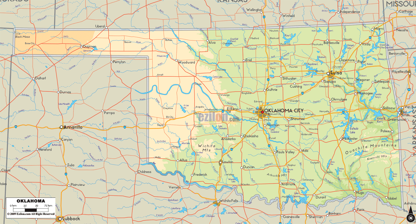

Description: The Physical map of Oklahoma State, USA showing major geographical features such as rivers, lakes, topography and land formations.
 Introduction:
Embarking on a journey with the Big Detailed Map of Oklahoma unveils a breathtaking location where the complete splendor of nature is evident. The meticulous craftsmanship embedded in this map sketches a vast tableau of compelling and educative topography.
The kaleidoscope of rivers, serene lakes, gentle hills, formidable mountains, and remarkable land formations strategically sprawled across Oklahoma's South, North, East, West, and Central areas beckons curious minds to traverse the scenic routes and contours vividly depicted. This introductory journey kindles a flame of exploration that illuminates the path leading to the heart of Oklahoma's geographical core.
Gazing southward on the map, the illustrious Arbuckle Mountains emerge as geological sentinels guarding tales of eons past. Their ragged contours are a testament to the forces of nature, beautifully depicted on the map to engage the curious mind. Alongside these ancient hills, the meandering Red River creates a natural boundary with Texas, its course a fluid ribbon of blue serenely cutting through the green expanse.
Amid this majestic terrain, the expansive Lake Texoma resplendently rests, offering aquatic escapades. Also noted are Lake Murray and Lake of the Arbuckles, other significant water bodies that add to the hydrological narrative of Southern Oklahoma. The geographical discourse provided by the map in this region showcases a vivid interplay between the ancient hills and life-sustaining rivers and lakes.
As the eyes wander north on the map, a change in scenery unveils the Great Salt Plains Lake and the Great Salt Plains. These saline wonders manifest a unique aspect of Oklahoma's topography. The way these plains stretch out seems almost endless, with the map highlighting their flat terrain and salty characteristics.
The Salt Fork Arkansas River finds a gentle mention, its course nurturing the surrounding lands and adding a fluid dynamic to the sturdy plains. The map also delineates the presence of the Cimarron River, adding another hydrological dimension to the terrain of Northern Oklahoma, all of which tell a fascinating story of adaptation and natural splendor.
The map reveals a picturesque terrain of undulating hills that gradually give way to the revered Ozark Mountains when traveling toward the east. This region is where lush foliage meets rocky outcrops, and rivers carve pathways through valleys. The Illinois River and Tenkiller Ferry Lake starkly contrast the hills, providing a fluid narrative amidst the ruggedness.
The map meticulously traces other notable geographical features like the Winding Stair Mountain, Rich Mountain, and the vividly depicted Robert S. Kerr Reservoir, further enriching the terrain's diverse narrative. The portrayal of these features tells a tale of a region where water and rock engage in a harmonious dance, crafting vistas that are nothing short of poetic.
The western domains of Oklahoma present a landscape that embodies the beauty of simplicity. As one explores the map, the vast expanses of the Black Kettle National Grassland appear as a verdant sea amidst an otherwise arid milieu.
The North Canadian River finds a distinct narrative here, its course a lifeline amidst the expansive plains. Additional rivers like the Beaver River and Wolf Creek are also elegantly sketched on the map, contributing to the hydrological tale of this region. This portion of the map celebrates the tranquility and austere beauty of the open plains and waterways to Oklahoma's physical landscape.
Central Oklahoma, the geographical heart of the state, exhibits a rich blend of natural and urban landscapes. The map elegantly highlights Lake Thunderbird and Arcadia Lake as serene water bodies around which the rhythms of nature and human endeavors synchronize harmoniously. The Canadian River winds through this central region, its banks nurturing flora and fauna.
The map here offers an eloquent narrative where the urban sprawl of Oklahoma City intermingles with the natural surroundings, creating a tableau that is both dynamic and serene. It's where the delicate veins of rivers, the calm expanse of lakes, and the gentle undulations of the land come together to write a geographical poem that resonates with every individual keen on exploring Oklahoma's heartland.
The journey through the Large, Detailed Physical Map of Oklahoma is a tribute to the state's geographical diversity. With its meticulously detailed rendering, the map invites individuals to immerse themselves in a realm where every river, lake, mountain, hill, and land formation tells a unique tale.
The bold etchings that represent these geographical features serve as a guide, offering a deeply immersive experience that fosters a profound understanding of Oklahoma's physical identity. As one navigates through this map, the essence of Oklahoma's physical narrative unfolds in a myriad of contours, colors, and geographical tales waiting to be explored and appreciated.
The presence of numerous natural resources in Oklahoma leads to the utilization of this map as a means for individuals to establish a connection with the land and its history.

Counties and Road Map of Oklahoma
Counties and Road map and map image of Oklahoma.

Regional Directory of Canada
Information and guide about Canada and website listing.

Regional Directory of United States of America
Information and guide about United States of America and websites with American topics.

Regional Directory of Europe
Information and guide about Europe and websites with European topics.

Regional Directory of Australia
Information and guide about Australia and websites with Australian topics.