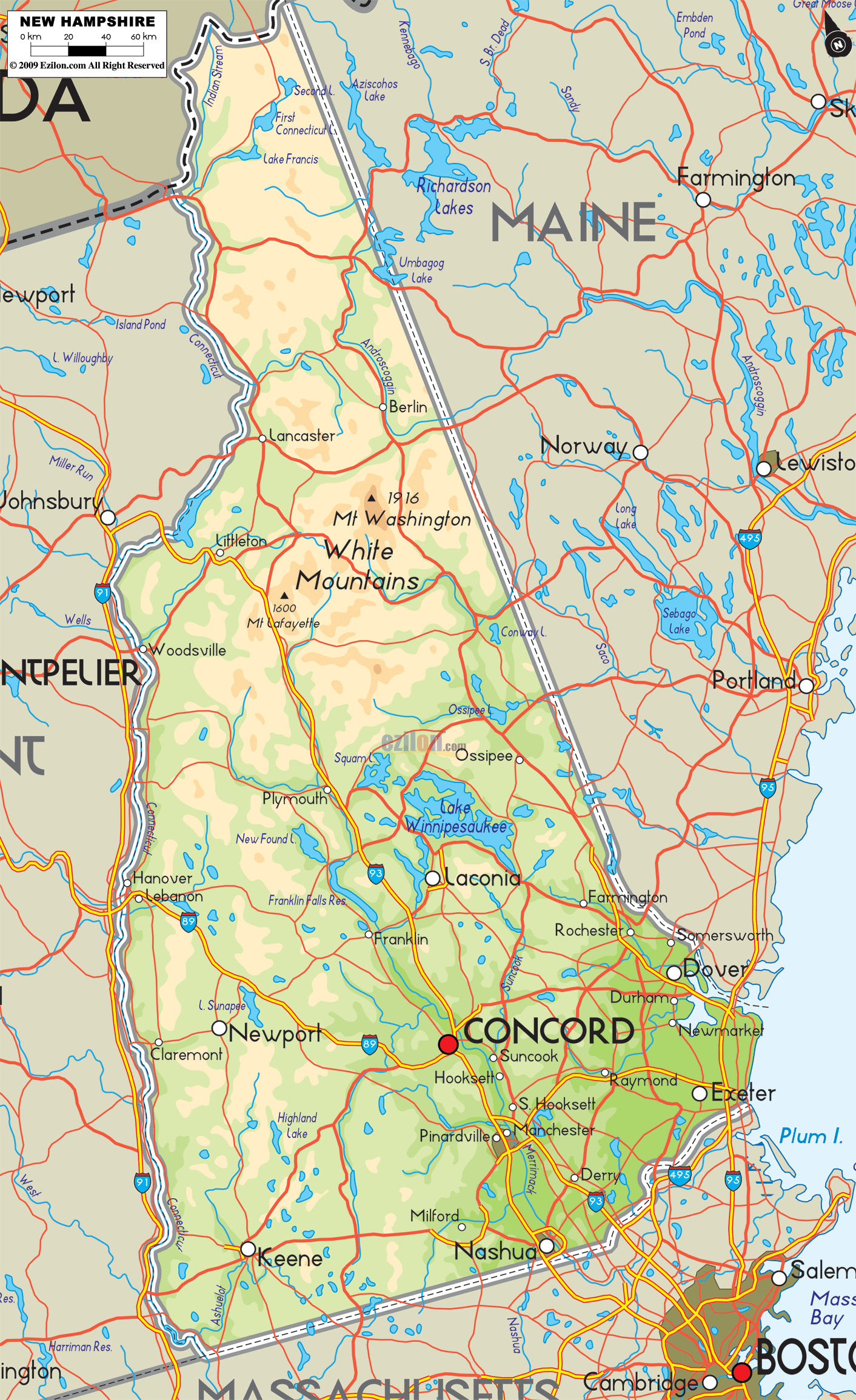

Description: The Large Detailed Physical map of New Hampshire State, USA showing major geographical features such as rivers, lakes, topography and land formations.
 Introduction:
Stepping into the tapestry of topographies that New Hampshire lays forth is akin to walking through a timeless narrative told through rocks, waters, and skies. The Large Detailed Physical Map of New Hampshire is not just a cartographic depiction but a lyrical ode to the diverse geographical splendors that define the Granite State.
From the craggy summits of the White Mountains to the gentle lull of the Merrimack River, each feature mapped out is a stanza in the state's endless poem of natural elegance. Through the cardinal directions - South, North, East, West - and the heartland, this map offers a scenic journey across New Hampshire's rich physical terrain, every contour line and water body not merely marked but narrated with a delicate touch of precision.
As one meanders through the southern domain of New Hampshire on the map, the serpentine flow of the Merrimack River holds the gaze. Originating in Franklin and flowing southward before making a northeastern turn, the river encapsulates the southern region's quiet beauty and geographical essence. The map meticulously marks the Merrimack's journey through prominent cities like Manchester and Concord, showcasing its integral role in the region's urban blueprint.
Within this portion, the map also brings to life the expanse of Massabesic Lake, a primary water supply for the nearby city of Manchester. The lake, nestled amidst a gently rolling landscape, reflects the subtler, serene side of New Hampshire's topography. The cartographic detail extends to more minor yet significant hills like Mine Hill and Federal Hill, unveiling the gentle undulations that characterize the southern landscape.
If you travel in a northern direction on the map, you will come across the White Mountains. The mountains become taller as you proceed further. This section richly illustrates the rugged grandeur of peaks like Mount Washington, the highest in the northeastern U.S., as a bold testament to the state's wild heart.
The mapping of Franconia Notch State Park with its well-known Franconia Ridge and the Presidential Range offers a deep dive into the alpine wonder that Northern New Hampshire embodies.
The rivers, too, change their demeanor; the Ammonoosuc and the Androscoggin rivers, with their intricately mapped courses, tell tales of ancient geology and the ceaseless carving of earth through time. The maps provide:
A comprehensive depiction of the magnificence and resilience of the northern region.
Showcasing every mountain pass.
River curve.
Valley.
The map's eastern frontier showcases a scenic coastline along the Atlantic Ocean, a stretch that, though brief, is replete with geographical marvels. The estuaries, bays, and iconic Portsmouth Harbor are depicted in fine detail, providing a picturesque view of New Hampshire's interface with the mighty Atlantic. Inland, the map brings forth the nuanced contours of the Lakes Region, notably Lake Winnipesaukee with its vast sprawl, offering a detailed visual ode to the lake's extensive shoreline and numerous islands.
The map's markings illustrate a progressive rise in terrain as we distance ourselves from the coastline, eventually culminating at the foothills of the White Mountains. It implies a transition from tranquil and flat coastal zones to more harsh and uneven landscapes that lie ahead.
The western exposition on the map unveils the serene flow of the Connecticut River, defining New Hampshire's border with Vermont. The river's journey is precisely etched, providing a fluid narrative of the land it traverses and nourishes.
The Monadnock Region, dominated by the solitary grandeur of Mount Monadnock, finds a distinct mention. The map delineates the mountain's lofty summit and surrounding highlands, part of the larger New England Upland.
The mosaic of smaller lakes and ponds, scattered like jewels across the landscape, is depicted with an eye for detail, each waterbody a small but significant part of the western region's geographical narrative.
At the heart of the map, central New Hampshire emerges as a convergence point of the state's diverse geographical elements. The Lakes Region, prominently featuring Lake Winnipesaukee and Squam Lake, forms the essence of this area. The map meticulously charts the sprawling water bodies, their myriad inlets, islands, and surrounding topographies.
Nestled amidst these aquatic expanses are modest hill ranges and individual peaks, each meticulously marked, narrating the gentle rise and fall of the land. Here, the convergence of water and earth creates a blend of landscapes emblematic of New Hampshire's diverse natural heritage.
The Large Detailed Physical Map of New Hampshire is more than a cartographic endeavor; it's a visual journey through the breathtaking physical geography that defines the Granite State. From the calm coastal stretches in the east to the wild, rugged heights in the north, the serene rivers and lakes in the south and west to the aquatic heart in the central, every feature is depicted with a clarity that enriches the understanding and appreciation of New Hampshire's geographical diversity.
Through Maps, every ridge, river, lake, and landform comes alive, narrating the ageless tale of New Hampshire's splendid natural canvas, making the experience not merely about viewing but understanding and connecting with the land's timeless essence.

Counties and Road Map of New Hampshire
Counties and Road map and map image of New Hampshire.

Regional Directory of Canada
Information and guide about Canada and website listing.

Regional Directory of United States of America
Information and guide about United States of America and websites with American topics.

Regional Directory of Europe
Information and guide about Europe and websites with European topics.

Regional Directory of Australia
Information and guide about Australia and websites with Australian topics.