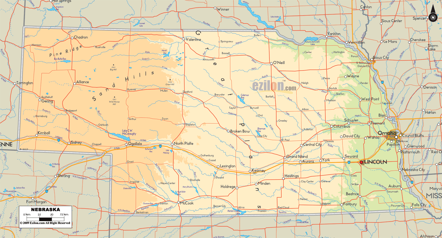

Description: The Physical map of Nebraska State, USA showing major geographical features such as rivers, lakes, topography and land formations.
 Introduction:
Embark on an educational and awe-inspiring odyssey through the boundless plains and gentle contours of the Cornhusker State with the Large Detailed Physical Map of Nebraska. Its meticulously curated Map encapsulates the myriad geographical wonders, a testament to the ancient, powerful forces that shaped this enchanting land over millennia.
As you meander from the rolling southern borders to the serene northern reaches and from the verdant eastern banks of the Missouri River to the rugged western escarpments, the Map encompasses the essence and the rich geographical narrative that Nebraska proudly boasts. This physical Map of Nebraska is not merely a map but a vibrant story told through the veins of rivers, the whispers of lakes, the stance of mountains, and the stretch of flat lands.
The thorough geographical exposition that follows is segmented by the South, North, East, West, and Central areas of Nebraska, offering a detailed discourse on the Map's nuanced depiction. As you delve into the following descriptions, each Map segment unfolds a part of Nebraska's geographical saga eloquently and illustratively.
Southern Nebraska is a picturesque canvas where gentle hills roll gracefully across the vast horizon, touching the sky at dawn and dusk. The Maps meticulously illustrate the significant presence of the Republican River, a ribbon of life that carves its way through the rich soil, nurturing the fertile farmlands along its banks. The detailed delineation of the river's course on the Map as it meanders through quaint towns and lush farmlands reflects its vital lifeline in this agrarian realm.
The Harlan County Reservoir emerges on the Map as a noteworthy water body, with its vast expanse of water providing both a source of irrigation for the surrounding agricultural lands and a haven for recreational activities. The Republican River cliffs delicately transform the otherwise level terrain, concealed within their sleek, contoured forms. The Map captures these features with delicate cartographic finesse, allowing one to traverse the tranquil scenery of Southern Nebraska.
The Prairie Dog Creek, a lesser-known yet significant waterway, is also prominent on the Map, highlighting the extensive network of rivers and creeks contributing to the region's topographical diversity.
The northern territories of Nebraska welcome you to Pine Ridge, where the earth rises to meet the sky in escarpments and rugged terrains. The Map meticulously traces the topographical transitions, providing a vivid contrast to the smoother landscapes of the southern regions.
With its winding journey, the Niobrara River forms an integral feature of the northern expanse. Its course through lush valleys and past rocky outcrops is marked with a fine delineation, inviting a deeper exploration of the region's geographical mosaic.
The Fort Niobrara National Wildlife Refuge, located near the town of Valentine, is another significant feature illustrated in the Map. It showcases the blend of ecological and geographical diversity that defines Northern Nebraska. The Keya Paha River, a lesser-known yet important waterway, is also depicted, contributing to the holistic representation of the region's hydrography.
In the eastern realm, the Map vividly portrays the ever-flowing course of the mighty Missouri River, forming a natural boundary between Nebraska and Iowa. The detailed delineation of this colossal waterway, coupled with its numerous tributaries like the Platte and Elkhorn Rivers, narrates a hydrogeographical tale integral to Nebraska's story. The Map accentuates the fertile floodplains that stretch along these rivers, a testament to the region's agricultural richness.
The topographical transition from the river valleys to the upland plains is marked with nuanced topographical lines, providing a well-rounded view of the eastern terrain. The Map also highlights the presence of smaller lakes and ponds scattered across the region, each contributing to the delicate hydrological balance of Eastern Nebraska.
As you venture westward on the Map, the landscape metamorphoses into a tableau of buttes, escarpments, and tablelands. The Map eloquently narrates this transition with detailed descriptions of geographical features like the Wildcat Hills, Pine Ridge, and the towering Scotts Bluff.
The cartographic detailing extends to the portrayal of Chimney Rock, a historical and geographical landmark that stands as a solitary sentinel amidst the expansive plains, witnessing the passage of time.
The North Platte River emerges as a significant hydrological feature, with its course marked as it threads through the rugged terrains and the gentle plains, acting as a vital artery pulsing through Western Nebraska. The Map also underscores the extensive network of smaller rivers, creeks, and water bodies that populate this region, offering a comprehensive view of the Western Nebraskan topography.
The heart of Nebraska's geographical essence pulsates in its central expanses. Here, the Platte River flows with timeless grace, its course meticulously etched on the Map, depicting its life-giving essence to the lands of Nebraska. The Platte River Valley, a vast and flat expanse, emerges as a significant geographical and agricultural hub, narrated eloquently through the Map's detailed depiction.
The Sandhills are beautifully illustrated with their undulating, grass-covered dunes, showcasing a unique and delicate ecosystem integral to Nebraska's identity. The Map depicts smaller water bodies, from tranquil lakes to ephemeral ponds, each narrating a part of Central Nebraska's geographical story.
The Large Detailed Physical Map of Nebraska is an ode to the geographical diversity and the rhythmic topographical transitions that define this magnificent state. The precision in depicting the curves of rivers, inclines of hills, and expanses of valleys reveals Nebraska's stunning natural scenery.
The Map, rich with physical geographical detailing, caters to the aesthetic appeal and invites a deeper understanding of the land's formation and ongoing, ever-evolving narrative. Through maps, one can embark on a delightfully vibrant exploration of Nebraska's heartland, traversing its flatlands, rivers, hills, and valleys.
While offering a thorough visual exploration that resonates with the captivating rhythms of this enchanting land, the invitation to explore, understand, and appreciate the geographical narrative of Nebraska is open to all who wish to delve into the rich, detailed description that the Map so eloquently unfolds.

Counties and Road Map of Nebraska
Counties and Road map and map image of Nebraska.

Regional Directory of Canada
Information and guide about Canada and website listing.

Regional Directory of United States of America
Information and guide about United States of America and websites with American topics.

Regional Directory of Europe
Information and guide about Europe and websites with European topics.

Regional Directory of Australia
Information and guide about Australia and websites with Australian topics.