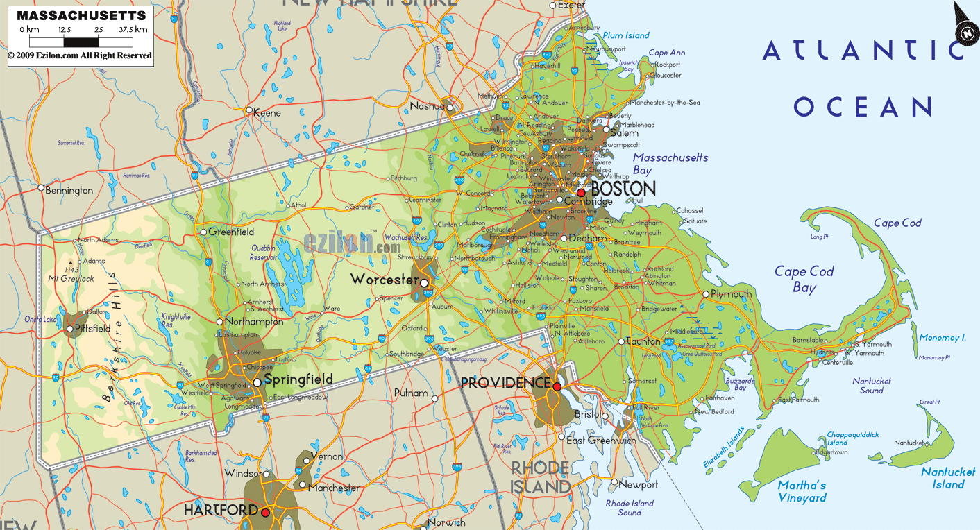

Description: The Physical map of Massachusetts State, USA showing major geographical features such as rivers, lakes, topography and land formations.
 An Exploration into the Rich Topographical Tapestry of the Bay State
Massachusetts, renowned for its historical significance and coastal beauty, is also home to a myriad of natural features that breathe life into its geographical expanse. This Large, Detailed Physical Map of Massachusetts offers an exhaustive insight into the state's vibrant terrain. Whether you're a curious traveler or an avid geographer, this comprehensive visual guide promises to pique your interest.
The southern region of Massachusetts is a captivating blend of marine topography and inland terrains. As you trace the coastline, you'll first encounter Buzzards Bay, a significant inlet of the Atlantic renowned for its shimmering blue waters and vibrant marine biodiversity. Parallel to this is the Taunton River, a gentle yet mighty flow that has carved many a canyon and valley in its path, shaping the terrain with its winding elegance.
Further exploring this coastal wonder, the islands of Martha's Vineyard and Nantucket emerge from the watery horizon. Each island, bathed in history, presents a unique topographical blueprint, from the low-lying sandy shores to the occasional rolling hill. The blend of beaches, marshlands, and quaint villages in the south provides a comprehensive overview of the state's coastal charisma.
Transitioning to the northern frontier of Massachusetts, the land rises, giving way to rugged landscapes and verdant hills. Dominating this terrain are the Taconic Mountains, a range that dictates the state's boundary and forms a protective barrier against external climatic influences. These mountains have valleys in between them. Ancient rivers and glaciers have left their tales within the valleys.
The Hoosic River, with its crystal-clear waters, further accentuates the beauty of the north. The river, originating from the heart of these mountains, holds significant importance in supporting the local flora and fauna. Maintaining diverse environments such as forests and farmlands contributes to various habitats' overall well-being and prosperity.
East Massachusetts is where the land passionately embraces the Atlantic. The Merrimack River holds significance in the historical development of Massachusetts. As it winds through Newburyport and Gloucester, it narrates stories of early settlers, trade routes, and the dawn of the industrial era.
The estuaries and deltas formed by this river have been vital for the state's marine and agricultural activities. Venturing further towards the ocean, the rugged beauty of Cape Ann unveils itself. Here, the landscape dramatically shifts from sandy dunes to jagged cliffs, each carved meticulously by the relentless waves of the Atlantic.
The western expanse of Massachusetts is a geographical masterpiece. Central to its identity is the Connecticut River Valley, a verdant stretch often bathed in a golden hue during sunsets. The Connecticut River, with its tributaries and brooks, acts as the lifeline of this region. Enveloping the river are expanses of meadows, wetlands, and occasional plateaus.
The Berkshire Hills further amplify the topographical diversity of the West. These hills, with their lush green cover and rocky outcrops, house several endemic species and are a haven for flora and fauna. Moreover, nestled within these landscapes are lakes like Lake Buel and Lake Garfield, reflecting the sky and surrounding terrains with pristine clarity.
Sitting right at the geographical heart of Massachusetts is its central region. This area is a melting pot of various topographies, with each feature contributing to its rich tapestry. The Quabbin Reservoir stands out as the most prominent landmark.
Beyond its role in supplying water, it's a marvel of engineering and nature, surrounded by dense woodlands and rolling hills. Rising prominently from these terrains is the Wachusett Mountain, a beacon for those seeking adventure and natural beauty. Streams from this mountain meander through the plains, filling up lakes and nurturing forests.
This Large, Detailed Physical Map of Massachusetts is an ode to nature's artistry. Every contour, the undulating Taconic Mountains, the sprawling shores of Buzzards Bay, or the dense woodlands surrounding the Quabbin Reservoir, showcases the state's unparalleled geographical splendor. Dive deep into this map, and you'll unearth tales of ancient times, witness nature's craftsmanship, and be inspired by the serene and the sublime.

Counties and Road Map of Massachusetts
Counties and Road map and map image of Massachusetts.

Regional Directory of Canada
Information and guide about Canada and website listing.

Regional Directory of United States of America
Information and guide about United States of America and websites with American topics.

Regional Directory of Europe
Information and guide about Europe and websites with European topics.

Regional Directory of Australia
Information and guide about Australia and websites with Australian topics.