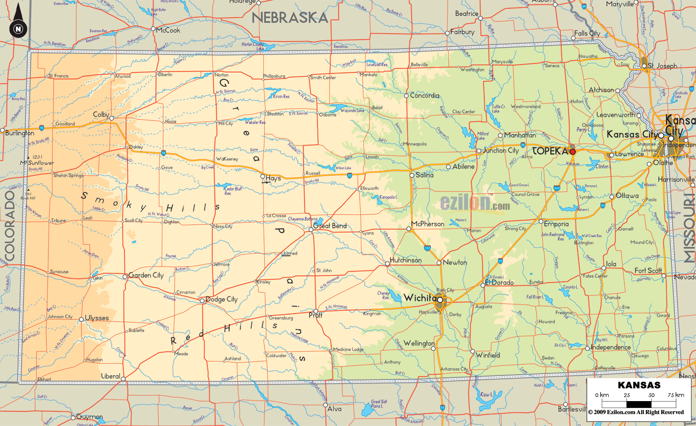

Description: The Physical map of Kansas showing major geographical features such as rivers, lakes, topography and land formations.

If you embark on a journey through the great American heartland, you'll be pleased to discover our Large, Detailed Physical Map of Kansas. Here, you'll find an unparalleled topographic tableau that meticulously outlines the land of wheat, sunflowers, and wide-open spaces.
The map's primary purpose is to accurately portray Kansas' scenery, offering a captivating experience to explore and admire the natural beauty. In this article, you will find comprehensive descriptions of the mountains in the East and the flat land in the West.
Its extensive High Plains predominantly mark west Kansas. However, as you follow the pathways of rivers like the Arkansas and Cimarron on the map, you'll note that even these seemingly "featureless" plains have unique characteristics. These rivers often represent the only significant breaks in an otherwise continuous stretch of semi-arid land.
Scott State Lake, located in Scott County, provides another point of interest. Its presence is prominently featured on the map, representing one of the few natural reservoirs in this region. Another intriguing detail is the Arikaree Breaks, a series of badlands along the Arikaree River near the Colorado border.
This map showcases these lesser-known geological formations with meticulous contour lines and shading. Highways like U.S. Route 50 and 83 are marked with utmost precision, helping you navigate this part of the state while being aware of your relative isolation from significant water sources. Western Kansas shares its borders with Colorado and Nebraska, and this map demarcates these state lines for easy identification.
The western portion of Kansas could be more sparse regarding state parks. However, the map explicitly highlights Scott State Park in Scott County. On the map, you'll notice it as a speck of intensified green, indicating its lush character amidst the semi-arid surroundings. The park is easily accessible via U.S. Route 83, meticulously outlined on the map. This park is near the Colorado border, providing a natural respite for those traveling to or from Colorado.
As you move into Central Kansas, the map's details will alert you to a shift in topography. The Great Bend of the Arkansas River becomes a central focal point as the river makes its majestic turn towards the southeast. Contrasting the West, this area is not a flat plateau but a region of subtle inclines, marking the beginning of the Flint Hills.
The Smoky Hills, represented in detailed contours on the map, is a more minor but equally intriguing land formation, appearing as a bridge between the flatlands of the West and the rolling hills of the East. Wilson Lake, Kanopolis Lake, and the Smoky Hill River make this region somewhat of a water-rich oasis compared to its western counterpart. Interstate 70 is the principal road traversing this region, annotated with significant landmarks, rest stops, and elevation points to aid travel planning.
In the central region of Kansas, you will encounter multiple state parks. Kanopolis State Park and Wilson State Park are two such examples. Kanopolis is situated southwest of Salina and is identified on the map by a tree symbol near the representation of Kanopolis Lake.
Wilson State Park can be found north of the I-70 and U.S. Route 281 junction and is similarly marked. These parks serve as central hubs for outdoor activities, and their clear marking on the map makes planning trips around these areas straightforward.
As you venture into Eastern Kansas, the map showcases the topographical magic of the Flint Hills, a range of hills that run from the northern border with Nebraska down to the Oklahoma state line. This region, replete with a bounty of rivers like the Kansas River and the Wakarusa River, is punctuated by Perry Lake and Clinton Lake, which serve as water reservoirs and recreational hubs.
Detailed contour lines reveal the subtle undulations of the landscape, including its highest point, Mount Oread, near the city of Lawrence. The Flint Hills are a significant prairie preserve, and the map offers specific labels identifying conservation areas and wildlife reserves. The critical roads here include U.S. Route 59 and U.S. Route 75, which provide excellent driving experiences through these verdant lands.
The map readily displays an abundance of state parks in eastern Kansas. Perry State Park and Clinton State Park are two of the most significant. Perry State Park is northwest of Lawrence, and you can easily access it via U.S. Route 24. Clinton State Park is located southwest of Lawrence and easily accessible via Clinton Parkway. Both are marked with tree symbols and situated next to their respective lakes, giving you an immediate sense of the water-based activities available.
The Northern part of Kansas is where you'll find a transitional geography, a melding between the flat High Plains and the more rolling terrain of the Smoky Hills. Cities like Concordia and Marysville lie in a hybrid land that exhibits features of both landscapes.
The Republican River enters this area, contributing to its water features. Here, the topographical lines also begin to fluctuate more, indicating a variance in elevations that wasn't present in the Western part of the state. Roads like U.S. Route 81 provide the main artery through Northern Kansas.
You'll find Lovewell State Park near the Nebraska border in the north. On the map, this is identified near U.S. Route 36, marked with a tree symbol adjacent to Lovewell Reservoir. The park's strategic location near the Nebraska border makes it a frequent stop for interstate travelers and is a testament to the map's comprehensive coverage of essential sites.
Lastly, Southern Kansas offers a mix of all the state's geographical elements. The Arkansas River continues its southeastward flow, passing through cities like Wichita. The land here varies dramatically, from flat plains suitable for agriculture to areas of more rugged, untamed nature like the Gypsum Hills near the Oklahoma border.
The Fall River is another significant water feature, adding more dynamism to the landscape. The Oklahoma border area is distinctly marked, and as you reach it, you'll see how Kansas' physical geography subtly blends into the Great Plains that continue southward.
In the south, near the Oklahoma border, the map features Elk City State Park, situated around Elk City Lake. A transparent green tree symbol marks its location on the map and is easily accessible via U.S. Route 160. Engaging in activities like fishing and hiking is possible in this park. Identifying its site in the surrounding area is relatively easy.
Our Large Detailed Physical Map of Kansas is not just a static representation of the state's geography; it's an interactive educational tool, an explorer's guide, and a nature lover's treasure. Through this cartographic masterpiece, you'll appreciate Kansas's diverse landscapes, from the expansive plains of the West to the hilly terrains of the East and everything in between.

Counties and Road Map of Kansas
Counties and Road map and map image of Kansas.

Regional Directory of Canada
Information and guide about Canada and website listing.

Regional Directory of United States of America
Information and guide about United States of America and websites with American topics.

Regional Directory of Europe
Information and guide about Europe and websites with European topics.

Regional Directory of Australia
Information and guide about Australia and websites with Australian topics.