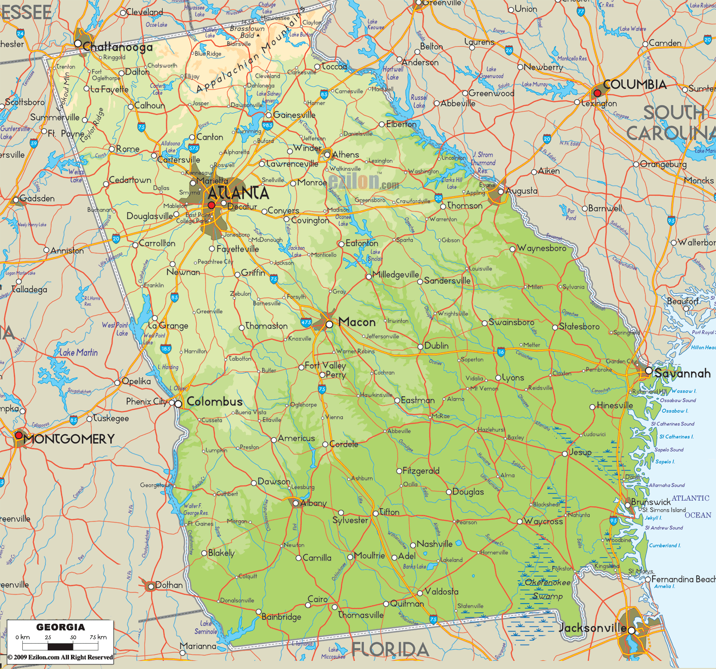

Description: The Physical map of Georgia State USA showing major geographical features such as rivers, lakes, topography and land formations.
 Georgia boasts stunning natural scenery that is truly awe-inspiring. The pathway stretches from the sandy beach to the higher ground, offering incredible vistas. By carefully curating the content, the physical map of Georgia State, USA comprehensively depicts the diverse terrains within the region, encompassing rivers, mountains, and other land formations. The purpose of it is to be a complete instructional handbook.
The map depicts every element, ranging from the loftiest mountain to the tiniest stream, making it easily visible to the observer. Below, let's engage with a more in-depth exploration of Georgia's five major geographical areas - Northern, Southern, Eastern, Western, and Central—to appreciate the map's scope and depth better.
At first glance, Northern Georgia might seem like a uniform block of elevated terrain, but the map showcases how multi-faceted this region is. You rapidly scan the elevations and crests of the Appalachian Mountains, including the Blue Ridge, Cohutta, and Tray Mountain ranges, among others. Not just mere representations of height and depth, the topographical details are so finely etched that one can virtually feel the terrain underfoot.
Notice how the map specifically marks the Dahlonega Plateau, which isn't just a plateau but a treasure trove of biodiversity and geological history. Georgia's loftiest point, Brasstown Bald's height and surrounding ridges and valleys meticulously labeled, is Dominating this high country.
The rich river systems, including the headwaters of the Chattahoochee River, the Chestatee, and the Soque Rivers, are mapped out with an attention to detail that reveals their courses, tributaries, and confluences. Make sure you look out for the lakes in this area, specifically Lake Lanier and Lake Chatuge. They will give you information about how deep they are and if there are any marinas or public entry areas.
As you transition southward on the map, the highlands gradually yield to the sprawling coastal plains. Among the many geographical treasures of Southern Georgia, the Okefenokee Swamp stands out, occupying significant real estate on the map. But the swamp is not just an indistinct mass; its numerous waterways, inlets, and islands are depicted in exceptional detail, making it almost a microcosm within the map.
Every river that originates from or courses through these plains, including the Withlacoochee, Alapaha, and Suwannee Rivers, is tracked carefully, with notations even on lesser-known tributaries. And it's not just the water bodies that grab attention here; the isolated ridges like the Trail Ridge are also meticulously represented, indicating their geological and ecological significance to the area.
Eastern Georgia is dominated by the Atlantic coastline, stretching from the Savannah River Basin near South Carolina to the St. Marys River by the Florida border. The map pays homage to this maritime legacy, detailing the barrier islands like Tybee, Jekyll, and Cumberland and highlighting the complex network of tidal creeks and salt marshes that make up the Intracoastal Waterway.
It's not just the natural features that get attention here; the map also hints at human activity in these areas, with ports like Savannah and Brunswick marked. Inland, the estuaries and deltas of rivers like the Savannah and Altamaha are meticulously mapped to their smallest distributaries, indicating their vital roles in Georgia's complex ecosystem.
In contrast to the north's ruggedness and the south's flat expansiveness, Western Georgia offers a medley of hills, valleys, and rivers. The map elegantly depicts how the Chattahoochee River is a lifeline in this region, creating a fertile valley around which towns and cities have grown.
The Flint River also plays a starring role, its journey culminating in the formation of Lake Seminole along the border with Florida. Even the less prominent streams, like the Oostanaula and Etowah, are given their due, each meander and bend demarcated.
Finally, the map's central region studies the harmony between land and water. The rolling hills gradually level off to form plateaus and river basins like the Ocmulgee and Oconee Rivers. These significant rivers, which merge to form the mighty Altamaha River, are accorded the detailed treatment they deserve, tracing their paths from their headwaters to their confluences.
The lakes in this region, notably Lake Oconee and Lake Sinclair, are more than just blue patches on the map; they are detailed enough to reveal depth variations, indicating their roles as recreational centers and vital ecological habitats.
In summation, this expansive, detailed physical map of Georgia transcends mere cartography; it is a geographical tome inviting exploration, offering the reader—from student to hiker, from environmentalist to casual admirer - a captivating and comprehensive guide to understanding and appreciating the natural splendor that is Georgia.

Counties and Road Map of Georgia
Counties and Road map and map image of Georgia.

Regional Directory of Canada
Information and guide about Canada and website listing.

Regional Directory of United States of America
Information and guide about United States of America and websites with American topics.

Regional Directory of Europe
Information and guide about Europe and websites with European topics.

Regional Directory of Australia
Information and guide about Australia and websites with Australian topics.