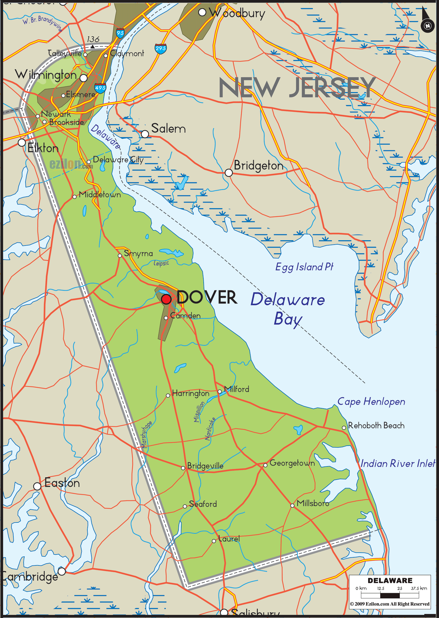

Description: The Physical map of Delaware State USA showing major geographical features such as rivers, lakes, topography and land formations.
 At first glance, Delaware's extensive, detailed physical map may seem like a simple depiction of a small state. Still, a closer look reveals an intricate mosaic of geological and hydrological features that weave together to form the unique character of Delaware.
In this narrative, we will delve deeper into the state's Southern, Northern, Eastern, Western, and Central regions, ensuring an immersive exploration beyond surface impressions. The objective is to facilitate a profound understanding of Delaware's rivers, lakes, and other significant landforms, each contributing to the state's geophysical diversity.
In the southern region of Delaware, the map meticulously highlights the gentle undulations of the coastal plain. While less dramatic than mountainous terrains, this flat topography has quiet grandeur. The most significant river in this region, without a doubt, is the Nanticoke River. It is much more than a waterway; it's an ecological tapestry.
The map marks its tributaries, including the well-known Broad Creek, each meandering through the flatlands and serving as the lifeblood for local flora and fauna. Trap Pond, Delaware's largest freshwater pond, earns a distinct marker. Surrounded by a picturesque expanse of woodlands, Trap Pond offers recreational opportunities like boating and fishing and serves as a critical aquatic ecosystem.
Besides, other smaller bodies of water, such as Hearns Pond and Concord Pond, may be less well-known but are equally vital for regional biodiversity. The map lets you appreciate the extensive network of wetlands that intersect these bodies, serving as water filtration systems and as habitats for wildlife.
The northern reaches of Delaware, displayed in crisp detail on the map, are an entirely different story. Here, the flat landscapes give way to the low-lying hills of the Brandywine Valley, whose green expanses and undulating terrain offer a welcome visual break.
The map traces the serpentine flow of the iconic Brandywine Creek, a river imbued with historical gravitas and ecological significance. Its main tributaries, the White Clay Creek and Red Clay Creek, are well indicated on the map, revealing their labyrinthine paths punctuating the hills and valleys.
The beauty and practicality of these streams make them ideal for engaging in various pursuits like hiking, kayaking, and bird spotting. Pike Creek and Naamans Creek are less known but still vital, each contributing its ecological importance to the region. The physical map demonstrates their significance in supporting local ecosystems and creating animal paths.
As your eyes drift towards the eastern part of the map, you'll observe how the state's boundaries unfold into an intricate coastline. Here lies the Delaware Bay, an estuarine system marked prominently on the map. This estuary, a blend of saltwater from the Atlantic Ocean and freshwater from rivers like the Mispillion and Murderkill, is a hub of biodiversity.
The estuarine system is so detailed that you can identify the channels and smaller bays, like the Little Delaware Bay, contributing to its complex geography. The coastal state parks, such as Cape Henlopen State Park and Delaware Seashore State Park, act as ecological buffers against sea-level rise and coastal erosion. These parks also provide an invaluable public recreation and education space, offering trails, beaches, and interpretive centers that make the coastal features accessible to everyone.
The western part of Delaware, as displayed on the map, is decidedly less aqueous but no less intriguing. The Mason and Dixon line, the historical boundary, is visibly etched, reminding us of its historical significance. While rivers like the Pocomoke and its tributaries, including Gum Branch and Beaverdam Creek, maybe fewer, their roles as part of the Chesapeake Bay watershed are profound.
These water bodies are crucial to regional agriculture and provide the necessary nutrients for the Chesapeake Bay, one of the most productive estuaries in the world. The land is gently rolling, offering an agricultural landscape dominated by corn, soybeans, and poultry farms. These elements, so subtly displayed on the physical map, play a critical role in the region's economic backbone.
Finally, the central region of Delaware emerges as a fulcrum that ties the state's diverse geological and hydrological features together. Dover, the state's capital, is a significant reference point on the map. The Smyrna River, flowing through this area, has an expansive web of tributaries and wetlands supporting natural habitats and human activities.
Spread across the region are lakes such as Silver Lake and Moores Lake, providing picturesque views and various activities. Their easily identifiable positions serve as reference points for comprehending the dissemination of water resources in the state's inner areas. Central Delaware, being a nexus, is also where major roads and highways intersect, offering a transportation network that makes the region an inevitable crossroad for commerce and communication.
In sum, this large, detailed physical map of Delaware is more than merely a tool for geographical reference. It is a storybook that narrates the tales of rivers that crisscross plains, valleys that nestle between hills, coasts that embrace the ocean, and wetlands that serve as the planet's kidneys.
Whether you are an academic, a naturalist, an adventurer, or a curious soul, the map offers a panoramic yet detailed view of Delaware's intricate geophysical profile, inviting you to explore and appreciate the state in its entire geospatial majesty.

Counties and Road Map of Delaware
Counties and Road map and map image of Delaware.

Regional Directory of Canada
Information and guide about Canada and website listing.

Regional Directory of United States of America
Information and guide about United States of America and websites with American topics.

Regional Directory of Europe
Information and guide about Europe and websites with European topics.

Regional Directory of Australia
Information and guide about Australia and websites with Australian topics.