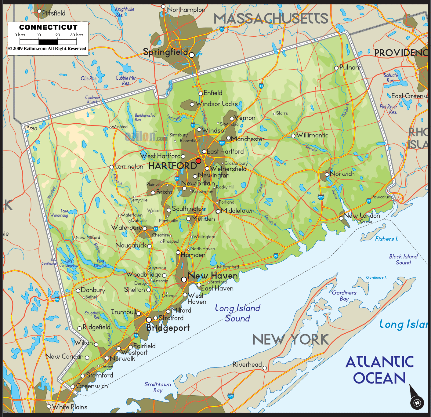

Description: Detailed physical map of Connecticut State USA showing major geographical features such as rivers, lakes, topography and land formations.
 Upon initial observation of Connecticut's map, one promptly discerns its level of intricacy and meticulousness. It isn't merely a representation of locations or points of interest; it's a narrative medium that substantially enriches your understanding of Connecticut's geography.
Its layout allows you to embark on an educational journey through Connecticut's regions - South, North, East, West, and Central - each brimming with unique geographical and topographical features. Let's elaborately journey through these parts, ensuring we delve deep into the rich geography that makes up this fascinating state.
The southern part of Connecticut delineated on the map, is a blend of high-energy urban life and serene natural beauty, offering an intriguing interplay of land and water. The majestic Long Island Sound is an estuary dominating this landscape, significantly influencing the state's geography and ecology. Within the Sound, you'll notice smaller bodies of water like Norwalk Harbor and Branford Harbor, which serve as gateways for maritime activities and are crucial for local ecosystems.
Cities like Greenwich and Stamford take full advantage of their coastal setting, offering both idyllic beach experiences and economic activity facilitated by their ports. In addition to the major rivers like the Connecticut River and Thames River that meander into the Sound, the map also indicates lesser-known yet significant rivers like the Saugatuck and Mill Rivers. These rivers and the estuaries they create contribute to the area's unique ecological tapestry, supporting a rich variety of plant and animal life.
As your eyes drift to the northern section of the map, the topography changes substantially. Dominated by the Metacomet Ridge, which includes significant features like Talcott Mountain and Ragged Mountain, the region combines high hills and low valleys. The Farmington River, one of the most pristine rivers in the state, weaves through these hills and valleys.
This river creates the Barkhamsted Reservoir and joins smaller rivers like the Still River, which are equally crucial for maintaining the region's hydrological balance. The northern part also boasts the Colebrook River and Mashapaug Lake, offering a rich panorama of recreational opportunities from boating to fishing. Small towns known as Suffield and Granby in this area have a lot of historical importance. The land's topography has a direct impact on the economy of these towns. The land's topography has a direct impact on the economy of these towns.
The eastern quadrant of the map focuses on a landscape that combines historical significance with geological splendor. At its heart is the Thames River, a vital natural highway that offers scenic beauty and maritime activity history. But the map also brings your attention to smaller rivers like the Yantic and Shetucket, which converge to form the Thames.
The sprawling Pachaug State Forest, an ecological marvel containing many indigenous flora and fauna, complements the region's waterways. Besides the forest, Eastern Connecticut is also home to Gardner Lake and Hopeville Pond, two bodies of water that are as important for their ecological functions as they are for leisure activities. The rolling terrain of the region provides an assortment of activities, such as hiking and mountain biking.
As your gaze settles on the western portion of the map, you'll note the prominence of the Housatonic River Valley. The river winds through a series of low but picturesque hills, collectively called the Litchfield Hills. Nestled within these undulations are several lakes, like Lake Candlewood—the largest artificial lake in the state—and Lake Lillinonah.
These lakes provide numerous recreational opportunities and serve as water reserves for surrounding communities. Lesser-known areas like Lake Zoar also contribute to the area's overall geographical character. The map also identifies charming communities like New Milford, Kent, and Ridgefield, each providing a different snapshot of life in Western Connecticut, shaped mainly by the natural geography surrounding them.
Finally, the central region of the map serves as a nexus where much of the state's physical geography converges. The Connecticut River is the star here, its course carefully delineated as it flows through the heart of the state. The river looks more noticeable because smaller rivers and streams flow into it, like the Mattabesset and the Coginchaug.
Each of these smaller bodies of water has unique ecological significance, adding layers to the map's complex geographical narrative. Hartford, the state's capital, is strategically located along the Connecticut River, serving as a cultural, economic, and political hub. Here, you'll also find Wethersfield Cove, a significant indentation in the river that is a haven for bird watchers and nature enthusiasts alike.
This long, extensively detailed description merely scratches the surface of what this large, detailed physical map of Connecticut offers. Whether you are a geography lover, an adventurous hiker, a curious student, or just someone captivated by nature's intricate patterns, this map is a comprehensive resource. Every body of water, every peak, every valley, and every ridge has its tale to tell, and this map serves as a complete storyteller.

Counties and Road Map of Connecticut
Counties and Road map and map image of Connecticut.

Regional Directory of Canada
Information and guide about Canada and website listing.

Regional Directory of United States of America
Information and guide about United States of America and websites with American topics.

Regional Directory of Europe
Information and guide about Europe and websites with European topics.

Regional Directory of Australia
Information and guide about Australia and websites with Australian topics.