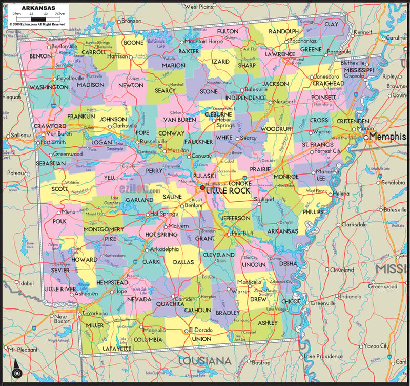
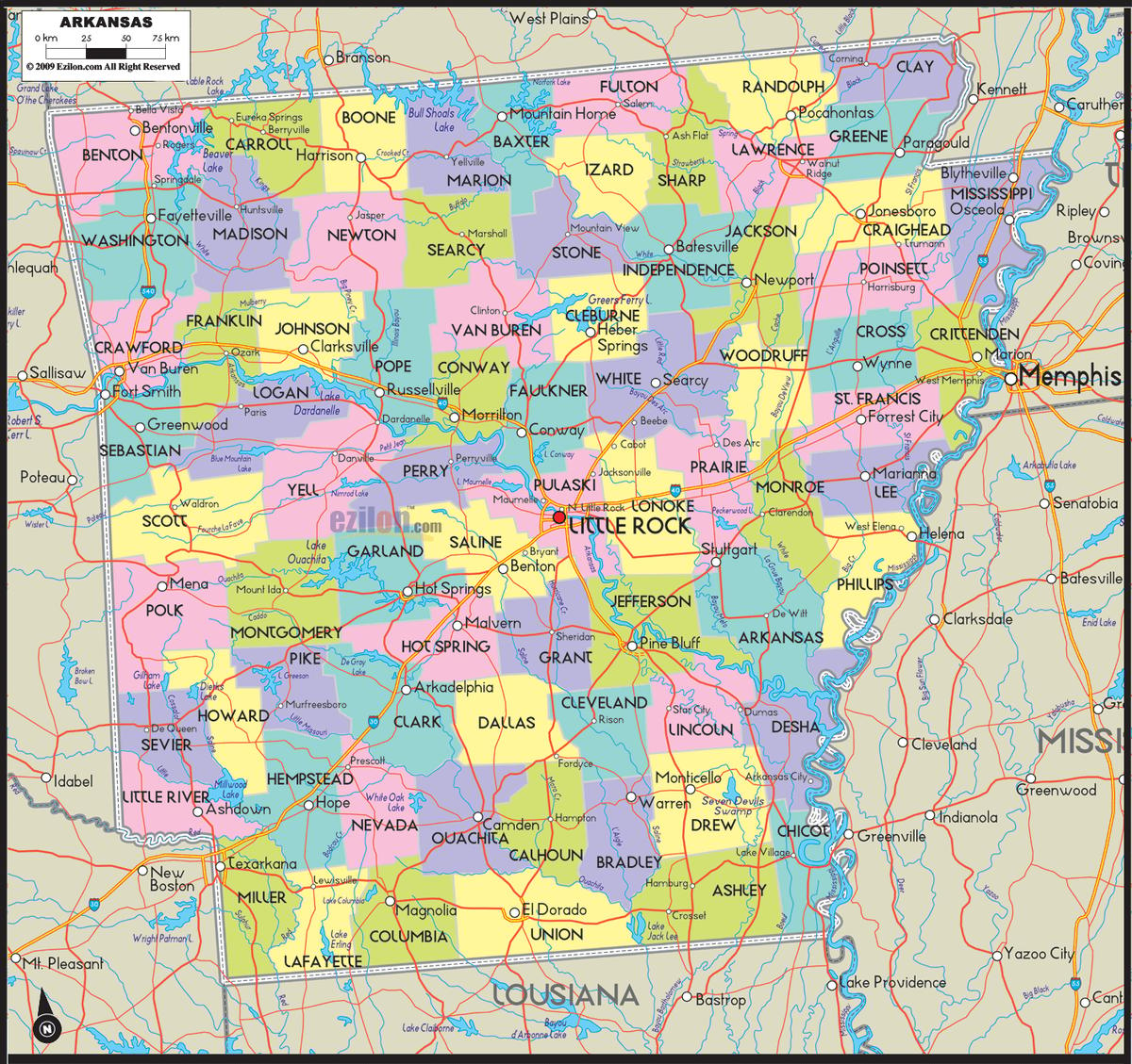
Description: Detailed large map of Arkansas showing cities, counties, towns, county seats, state boundaries and a light interstate reference layer.

Map of Arkansas (USA). Arkansas map with cities, counties, and towns. Use this detailed map to understand Arkansas’s full county grid, every administrative capital (county seat), the major cities and towns, bordering states and waters, and a few highway cues for orientation only. It is the best map style for residents, travelers, and geography students who want clarity without road clutter. Arkansas packs 75 counties into a little over 53,000 square miles, more counties than most states its size carry, so the map leans on color instead of a maze of route numbers to keep all of that readable. The shading and the bold seat label are really what you need to place a town, and the thin road lines underneath are just there for context — start with the color blocks and the roads will make sense on their own.
Borders and waters at a glance: Missouri runs the entire top edge of the map, from Benton County in the northwest corner to Clay County in the northeast. Cross the Mississippi River east and you are looking at Tennessee, near Mississippi and Crittenden counties, and the state of Mississippi itself continues along that same river line south past Lee, Phillips, Desha, and Chicot counties. Louisiana closes off the bottom near Miller, Lafayette, Columbia, Union, Ashley, and Chicot counties, while Texas and Oklahoma run the full length of the west side. Inside those borders, four rivers are worth remembering: the Arkansas, White, Mississippi, and Ouachita. They do most of the work of cutting this state into pieces you can actually picture.
Road-light orientation: Only five interstates carry the weight on this map, and that is on purpose. I-40 crosses the north-central corridor east to west, I-30 angles southwest toward Texarkana, I-49 serves the fast-growing northwest corner, I-55 runs the eastern Delta edge, and its short I-555 spur peels off into Jonesboro. Learn those five lines and you can place almost any city on this page without needing a full road atlas next to it.
Arkansas borders Missouri to the north, Tennessee and Mississippi to the east across the Mississippi River, Louisiana to the south, and Texas and Oklahoma to the west. This Arkansas map with counties and cities shows all 75 counties. Union County is the largest by land area at about 1,039 square miles, while Lafayette County is the smallest at about 526 square miles. Pulaski County is the most populous at roughly 401,209 residents, and Calhoun County is the least populous at roughly 4,690 residents. Arkansas County, established in December 1813, is the oldest county in the state, formed before Arkansas itself became a separate territory. The state covers about 53,179 square miles in total, with about 52,035 square miles of land. The capital, Little Rock, sits in Pulaski County at the bend of the Arkansas River, and this Map of Arkansas major cities picture continues from the Northwest Arkansas corridor of Fayetteville, Springdale, Rogers, and Bentonville through Fort Smith and the capital to Jonesboro in the northeast. Landscape-wise, the state moves from the Ozark Plateau and Ouachita Mountains in the west and north, through the Arkansas River Valley at the center, to the flat Delta lowlands of the Mississippi Alluvial Plain in the east and southeast.
This Map of Arkansas counties lists every one of the state’s 75 counties alongside its seat, in alphabetical order: Arkansas–DeWitt and Stuttgart; Ashley–Hamburg; Baxter–Mountain Home; Benton–Bentonville; Boone–Harrison; Bradley–Warren; Calhoun–Hampton; Carroll–Berryville and Eureka Springs; Chicot–Lake Village; Clark–Arkadelphia; Clay–Piggott and Corning; Cleburne–Heber Springs; Cleveland–Rison; Columbia–Magnolia; Conway–Morrilton; Craighead–Jonesboro and Lake City; Crawford–Van Buren; Crittenden–Marion; Cross–Wynne; Dallas–Fordyce; Desha–Arkansas City; Drew–Monticello; Faulkner–Conway; Franklin–Ozark and Charleston; Fulton–Salem; Garland–Hot Springs; Grant–Sheridan; Greene–Paragould; Hempstead–Hope; Hot Spring–Malvern; Howard–Nashville; Independence–Batesville; Izard–Melbourne; Jackson–Newport; Jefferson–Pine Bluff; Johnson–Clarksville; Lafayette–Lewisville; Lawrence–Walnut Ridge; Lee–Marianna; Lincoln–Star City; Little River–Ashdown; Logan–Booneville and Paris; Lonoke–Lonoke; Madison–Huntsville; Marion–Yellville; Miller–Texarkana; Mississippi–Blytheville and Osceola; Monroe–Clarendon; Montgomery–Mount Ida; Nevada–Prescott; Newton–Jasper; Ouachita–Camden; Perry–Perryville; Phillips–Helena-West Helena; Pike–Murfreesboro; Poinsett–Harrisburg; Polk–Mena; Pope–Russellville; Prairie–Des Arc and DeValls Bluff; Pulaski–Little Rock; Randolph–Pocahontas; Saline–Benton; Scott–Waldron; Searcy–Marshall; Sebastian–Fort Smith and Greenwood; Sevier–De Queen; Sharp–Ash Flat; St. Francis–Forrest City; Stone–Mountain View; Union–El Dorado; Van Buren–Clinton; Washington–Fayetteville; White–Searcy; Woodruff–Augusta; Yell–Dardanelle and Danville.
Look at the top left corner of the map and you will see the state’s busiest growth story packed into two counties. Benton County, seat Bentonville, is where Walmart keeps its headquarters, and the suburbs around it, Rogers and Siloam Springs among them, have been sprinting to keep up. Right below it, Washington County, seat Fayetteville, is home to the University of Arkansas and actually shares the Springdale city label with Benton County across the line between them, which is why the two counties read almost as one metro area on the map. Together, Fayetteville, Springdale, Rogers, and Bentonville form one of the fastest-growing corridors in the country. Climb east and the map changes character fast: Madison County, seat Huntsville, and Carroll County, seats Berryville and Eureka Springs, trade the flat suburban grid for steep Ozark valleys and curving roads. US-71, US-62, and US-412, alongside the I-49 corridor, are what thread the whole region together.
Follow the Missouri line east from there and Boone County, seat Harrison, opens into Marion County, seat Yellville, and Baxter County, seat Mountain Home, where two of the map’s biggest blue shapes, Bull Shoals Lake and Norfork Lake, take over the landscape. Fulton County, seat Salem, Izard County, seat Melbourne, and Stone County, seat Mountain View, round out this northern lake belt, and Mountain View in particular is worth knowing for its Ozark Folk Center and its mountain music tradition. Drop south of the lakes and you will notice the roads thin out noticeably around Searcy County, seat Marshall, and Newton County, seat Jasper, which is really just the map reflecting how steep and winding the Buffalo National River country gets through both of them. Van Buren County, seat Clinton, sits just below, bridging the Ozark uplands above it to the Arkansas River Valley further south.
Trace the White River on the map and it carries you through Independence County, seat Batesville, then on to Jackson County, seat Newport. Further northeast, Lawrence County, seat Walnut Ridge, Sharp County, seat Ash Flat, and Randolph County, seat Pocahontas, sit right where the Ozark uplands flatten out toward the Delta. Tucked into the far northeast corner, Clay County actually carries two seats, Piggott and Corning, while Greene County, seat Paragould, and Craighead County, seats Jonesboro and Lake City, mark the biggest concentration of population in the whole region. Jonesboro, Arkansas’s fifth-largest city, anchors that corner, and you can reach it on the map via US-63, US-49, or the I-555 spur off I-55.
Slide over to the river’s edge and Mississippi County is the first thing you will notice, it carries two seats, Blytheville and Osceola, both sitting close against the water. Just south, Crittenden County, seat Marion, holds West Memphis, directly across the river from Memphis, Tennessee, right where I-40 and I-55 both cross the state line. Move inland and Poinsett County, seat Harrisburg, and Cross County, seat Wynne, sit between the St. Francis and Cache rivers, while St. Francis County itself, seat Forrest City, lands on I-40 about halfway between Little Rock and Memphis.
Right at the Oklahoma line, Fort Smith anchors Sebastian County, seats Fort Smith and Greenwood, sitting directly across the river from Van Buren, the seat of Crawford County. I-40 crosses the state line at exactly this point, with US-64 running parallel along the river’s north bank. Follow the valley east and Franklin County, seats Ozark and Charleston, and Scott County, seat Waldron, stretch toward the Ouachita foothills. Johnson County, seat Clarksville, and Pope County, seat Russellville, face each other across Lake Dardanelle, the broad reservoir on the Arkansas River where Russellville and Dardanelle sit on opposite banks. Logan County carries two seats of its own, Booneville and Paris, and Yell County, seats Dardanelle and Danville, reaches south toward Mount Magazine, the highest point anywhere in the state.
Keep moving east and Conway County, seat Morrilton, and Perry County, seat Perryville, lead you straight into Pulaski County, where Little Rock and North Little Rock sit at the bend of the Arkansas River. This is the busiest intersection on the whole map: I-30, I-40, I-430, I-440, and I-530 all meet here, along with US-65, US-67, and US-167. Just north of the capital, Faulkner County, seat Conway, is home to Arkansas’s eighth-largest city. Ringing the capital on the map, Saline County, seat Benton, and Grant County, seat Sheridan, sit to the southwest, while Lonoke County, seat Lonoke, and White County, seat Searcy, stretch east toward the Delta. North of the metro, Cleburne County, seat Heber Springs, holds Greers Ferry Lake, a popular spot for boating and fishing fed by the Little Red River.
Head southwest from the capital and Garland County, seat Hot Springs, comes into view framed by Lake Hamilton and Lake Ouachita, with the historic bathhouses of Hot Springs National Park still drawing visitors year-round. Hot Spring County, seat Malvern, sits along I-30 on the way in from Little Rock. Push deeper into the mountains and Montgomery County, seat Mount Ida, Polk County, seat Mena, and Pike County, seat Murfreesboro, near the Crater of Diamonds, get noticeably more sparsely populated on the map, while Clark County, seat Arkadelphia, marks the spot where the Ouachita River meets I-30.
Howard County, seat Nashville, and Sevier County, seat De Queen, lead you down into Little River County, seat Ashdown, where the Red River marks the approach to Texas. Hempstead County, seat Hope, and Nevada County, seat Prescott, sit along I-30, and Lafayette County, seat Lewisville, the smallest county on the map by land area, touches both Texas and Louisiana at once. Right at the southwest corner, Miller County anchors Texarkana, exactly where I-30 crosses into Texas.
Columbia County, seat Magnolia, and Union County, seat El Dorado, the largest county on the map by land area, anchor the oil and timber economy of the far south. Ouachita County, seat Camden, and tiny Calhoun County, seat Hampton, the least populous county in the state, sit inland along the Ouachita River. Dallas County, seat Fordyce, Bradley County, seat Warren, known for its pink tomatoes, and Cleveland County, seat Rison, round out the forested belt just north of El Dorado.
Southeast of the capital, Jefferson County, seat Pine Bluff, sits right on the lower Arkansas River, reached by I-530. Lincoln County, seat Star City, and Drew County, seat Monticello, lead down toward Ashley County, seat Hamburg, a major timber and paper-mill county, and Chicot County, seat Lake Village, which curls around an oxbow of the Mississippi River at Lake Chicot. Desha County, seat Arkansas City, with Dumas and McGehee as its larger towns, sits downriver from there, while Lee County, seat Marianna, and Phillips County, seat Helena-West Helena, carry the river’s blues heritage, Helena being home to the King Biscuit Blues Festival every October.
Prairie County carries two seats, Des Arc and DeValls Bluff, straddling the White River floodplain on the map. Arkansas County, the oldest county in the state, carries two seats of its own, DeWitt and Stuttgart, which calls itself the rice and duck-hunting capital of Arkansas. Monroe County, seat Clarendon, and Woodruff County, seat Augusta, round out the Grand Prairie, a stretch of rice fields, duck blinds, and slow bayous where the Cache and White rivers do most of the navigating for you.
Four features carry almost all of the orientation weight on this map. The Arkansas River runs west to east straight through Fort Smith, Little Rock, and Pine Bluff. The White River curves down out of the Ozarks and through the Delta. The Mississippi River forms the entire eastern border. And the Ouachita River drains the southern mountains toward Louisiana. Learn those four, keep the Ozark and Ouachita highlands in mind to the west and north and the Delta lowlands to the east and southeast, and almost any county on this map becomes easy to place.
A standard road map would crowd Arkansas with thousands of miles of state highway and county road detail that most people never actually need. This one takes the opposite approach: 75 counties as solid color blocks, every seat marked clearly, with only the interstate system and a handful of major US routes left in as light reference lines. Look at the map this way and the questions people actually search for, which county a city sits in, where one county ends and the next begins, which county touches a particular border or river, get answered faster than a cluttered turn-by-turn road map ever could manage. If you need actual driving directions, a GPS app is still the better tool for that job. If you want to understand how Arkansas is put together, county by county, this is the clearer picture.
Arkansas’s ten largest cities on the map, by current population, are Little Rock (about 202,591, Pulaski County), Fayetteville (about 93,949, Washington County), Fort Smith (about 89,142, Sebastian County), Springdale (about 84,161, Washington and Benton counties), Jonesboro (about 78,576, Craighead County), Rogers (about 69,908, Benton County), North Little Rock (about 64,591, Pulaski County), Conway (about 64,134, Faulkner County), Bentonville (about 54,164, Benton County), and Pine Bluff (about 41,253, Jefferson County). Bentonville is where Walmart, the world’s largest retailer, keeps its headquarters, and the Benton-Washington county corridor around it has grown into a real logistics and technology hub. Springdale is home to Tyson Foods, and poultry processing runs straight through Washington, Benton, and Sebastian counties. Little Rock anchors state government, finance, and health care on the map, while Jonesboro’s Craighead County works as the commercial hub for northeast Arkansas’s rice and soybean farmland. The Grand Prairie counties, Arkansas, Prairie, and Lonoke, lead the nation in rice production, and timber still drives the economy in Union, Ashley, Bradley, and Ouachita counties down south.
Trace the cultural map of Arkansas and it runs from the Ozark Folk Center in Stone County all the way to the blues heritage of Helena in Phillips County, home every October to the King Biscuit Blues Festival. Hot Springs, in Garland County, built its whole identity around the bathhouses of Hot Springs National Park and these days also hosts a well-known documentary film festival. In the capital, Little Rock’s River Market District and the William J. Clinton Presidential Library have been pulling in visitors since the early 2000s. Higher education is spread across the map too: the University of Arkansas sits in Fayetteville (Washington County), Arkansas State University in Jonesboro (Craighead County), and both the University of Central Arkansas and Hendrix College in Conway (Faulkner County). Up in Northwest Arkansas, the Crystal Bridges Museum of American Art, built with Walmart family funding in Bentonville, has become a major draw for Benton County.
On this map, the Ozark and Ouachita highlands to the west and north and the Delta lowlands to the east and southeast double as quick landmarks for finding a county, with the Arkansas, White, and Mississippi rivers acting as your navigation lines. For elevation, terrain, watersheds, and land-cover detail, see our Physical Map of Arkansas.
Arkansas runs a humid subtropical climate statewide, though temperatures stay noticeably milder up in the Ozark and Ouachita highlands than they do down in the Delta lowlands. See our Physical Map of Arkansas for the full seasonal breakdown.
North-south travel leans on I-49 in the northwest and US-65 through the center of the state, while east-west travel runs on I-40 across the north-central corridor and I-30 through the southwest toward Texarkana. I-55 and its I-555 spur cover the northeast Delta and Jonesboro. One thing worth knowing: Arkansas’s ZIP codes do not follow county lines, so a single ZIP can span two counties. When in doubt, check the county name against the map or the index rather than guessing from a ZIP prefix.
Arkansas has 75 counties, and the map shows every one with a colored block and its county seat labeled.
Little Rock is the state capital, located in Pulaski County at the bend of the Arkansas River.
Pulaski County holds both Little Rock and North Little Rock, Arkansas’s largest metro area.
Washington County, in the heart of Northwest Arkansas.
Sebastian County, on the Oklahoma border along the Arkansas River.
Springdale sits mainly in Washington County, while Rogers and Bentonville are in Benton County.
Craighead County, the commercial hub of northeast Arkansas.
Garland County, home to Hot Springs National Park and Lake Hamilton.
Miller County, right on the Texas state line.
Jefferson County, along the lower Arkansas River southeast of Little Rock.
Faulkner County, just north of the Little Rock metro area.
Baxter County, near Bull Shoals Lake and Norfork Lake in the Ozarks.
Union County, Arkansas’s largest county by land area, in the south Arkansas Timberlands.
Crittenden County, across the Mississippi River from Memphis, Tennessee.
Benton, Carroll, Boone, Marion, Baxter, Fulton, Randolph, and Clay counties line the Missouri border.
Benton, Washington, Crawford, Sebastian, Scott, Polk, Howard, Sevier, and Little River counties.
Miller, Little River, and Sevier counties sit along the Texas line near the Red River.
Miller, Lafayette, Columbia, Union, Ashley, and Chicot counties.
Mississippi County and Crittenden County, near Memphis.
Crittenden, Lee, Phillips, Desha, and Chicot counties along the lower river.
I-40, I-30, I-49, I-55, and I-555 are shown as light reference lines, not turn-by-turn routes.
Union County, at about 1,039 square miles in the south Arkansas Timberlands.
Lafayette County, at about 526 square miles in the southwest corner.
Pulaski County, with about 401,209 residents, home to Little Rock.
Calhoun County, with about 4,690 residents, in south-central Arkansas.
Little Rock, in Pulaski County, with about 202,591 residents.
Arkansas County, established in December 1813, the first county formed in the territory.
No. ZIP codes cross county lines, so use the county boundaries and seats shown here instead.
No. Printing or copying maps from this site is not permitted.
Benton, Washington, Madison, and Carroll counties, anchored by Bentonville, Rogers, Springdale, and Fayetteville.
Through Newton and Searcy counties, between Harrison and Marshall.
Bull Shoals, Norfork, Greers Ferry, Lake Dardanelle, Lake Ouachita, Lake Hamilton, and Lake Chicot.

Physical Map of Arkansas
Physical map and map image of Arkansas.

Regional Directory of Canada
Information and guide about Canada and website listing.

Regional Directory of United States of America
Information and guide about United States of America and websites with American topics.

Regional Directory of Europe
Information and guide about Europe and websites with European topics.

Regional Directory of Australia
Information and guide about Australia and websites with Australian topics.
