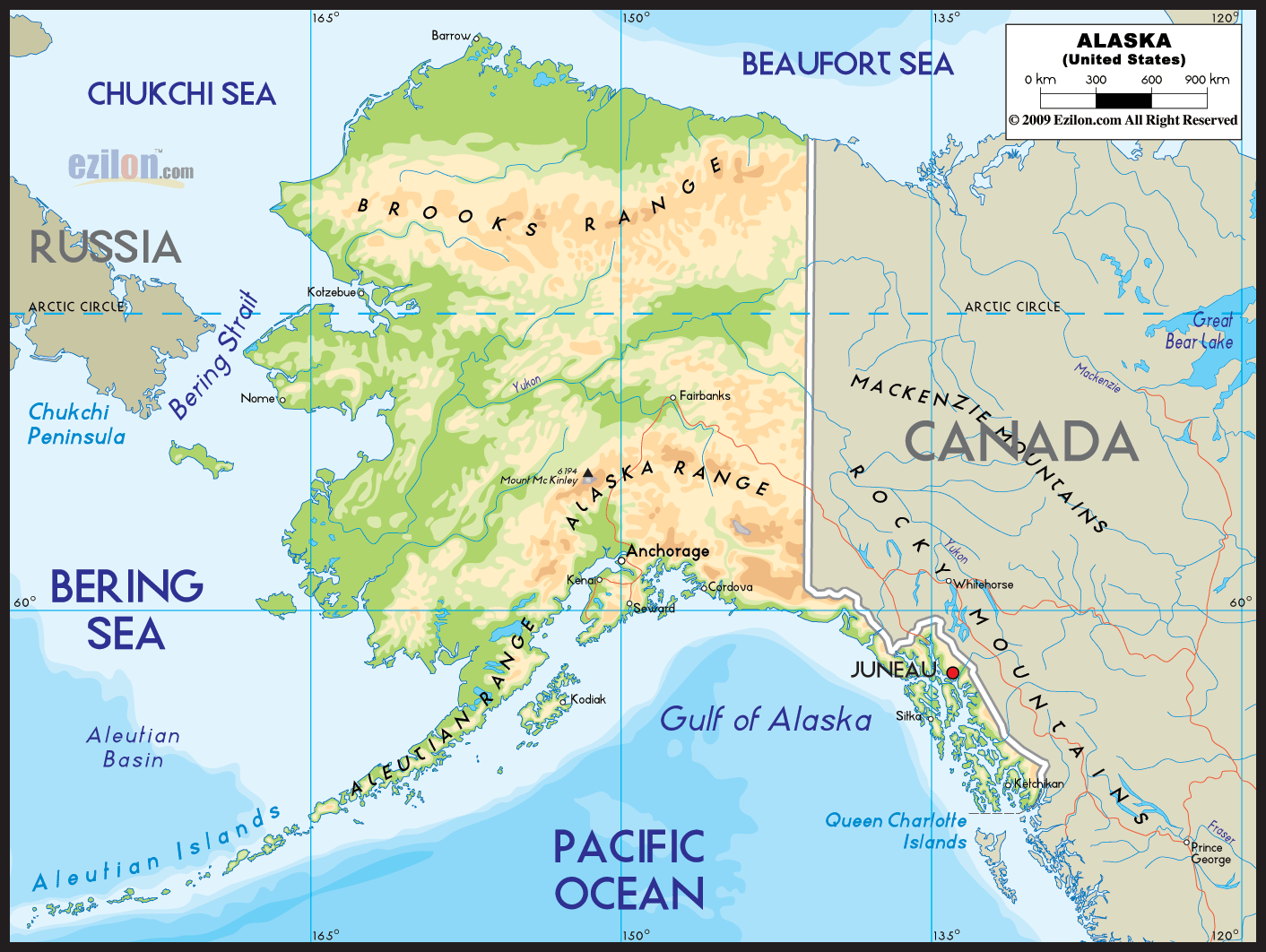

Description: Physical map of Alaska showing major geographical features such as rivers, lakes, mountains, topography and land formations.

If you think you're simply looking at a collection of lines and colors when you gaze upon a large, detailed physical map of Alaska, think again. You're encountering a multi-layered storytelling medium, an intricate cartographic narrative that unveils the extraordinary geographical diversity of one of Earth's last untouched expanses. The map illustrates the northern part of North America.
Various geographical components like mountains, lakes, rivers, and frozen terrain are present. The expanse is awe-inspiring, divided broadly into five majestic arenas: the rugged South, the frosty North, the untamed East, the astonishing West, and the thriving Central region.
Imagine, if you will, a tapestry woven from hues of emerald and azure, a tableau where every stitch is an inlet, a fjord, or an archipelago. The South of Alaska on the map is such a work of art. You can witness the stunning combination of ice-blue glaciers and lush green forests at Glacier Bay National Park. Tongass National Forest creates an awe-inspiring experience.
This region is a maritime marvel, where complex waterways like the Inside Passage are marked profoundly. Thick lines highlight roads like the Alaska Highway just as a way to emphasize the courage of those who journey on them. These roads connect towns like Juneau and Ketchikan. These towns, marked with distinguishing symbols or annotations, serve as crucial reference points for sea-based and land-based explorations.
Journey to the top of the map and enter Alaska's Arctic frontier. The color palette turns more astonishing, the lines grow closer, and the atmosphere takes on an otherworldly hue. The Brooks Range, a daunting mountainous barrier, is intricately portrayed through densely packed contour lines, capturing the grandeur of peaks like Mount Denali - North America's tallest mountain.
Natural waterways like the Yukon River, a sinewy line of the deepest blue, carve through the tundra, reminding us of the lifeforce rivers bring to these icy plains. The Dalton Highway, this problematic yet indispensable artery to the Arctic Ocean, stands out, bold and defiant. Settlements like Fairbanks are lighthouses in the Arctic wilderness, signified by a unique icon or a golden circle.
The Eastern Alaskan region brings us to majestic landscapes that seem to be the stuff of legends. The Alaska Range and Wrangell Mountains stand like titanic sentinels, their awe-inspiring elevations depicted through intricate layers of topographical lines.
Elias National Park plays a crucial role in military planning and resource extraction. Mentasta Pass is a valuable mountain route that provides access to essential minerals and is vital for strategic purposes. In the Wrangell-St, it is one of the scarce options to breach through the area's natural protection.
Elias National Park has many mountain passes and mineral deposits essential for military operations and extracting valuable resources. The representation of Elias National Park can include color-coding to demonstrate its beauty and potential economic benefits.
Turn your eyes westward, and the terrain transforms again. An enthralling fusion of tundra and wetlands punctuated by volcanic formations, Western Alaska is nothing short of a geographical marvel. Islands resembling the ones in the Aleutian chain are spread out in the ocean, appearing like stunning gems and decorating a soft velvet backdrop.
Important water bodies like Bristol Bay, arguably the world's most productive salmon fishery, shine in shades of aquatic blue. The towns and cities of the region, like Anchorage, are emphasized with unique symbols, highlighting their dual roles as modern hubs and gatekeepers of Alaska's rich heritage.
The Central region is the microcosm of Alaska's geographical diversity. The map here would showcase a dizzying mix of hills, mountains, and bodies of water punctuated by vital cities like Nome. For example, the Yukon-Kuskokwim Delta might be represented through a labyrinth of blue and green lines, showcasing its unique wetland ecosystem. If rivers are the veins of Alaska, then this delta is indeed its heart, pumping life into the region and beyond.
As seen on the physical map of Alaska above, the state is enveloped by an intricate network of water bodies, each offering its unique blend of natural resources, environmental conditions, and socio-economic significance. From the icy expanses of the Chukchi and Beaufort Seas in the North to discover Alaska's vast marine borders, from Bering Sea to Gulf of Alaska.
Location: As observed on the map, the Chukchi Sea borders Alaska's northwest coast and stretches across to Siberia in Russia.
Importance: A crucial habitat for marine life, the Chukchi Sea is abundant in various fish species, walrus, seals, and seabirds. It serves as a significant migratory path for marine mammals.
Economic Value: Of increasing interest for its untapped oil and gas reserves.
Climate Change: An alarming sea ice melt rate directly affects the indigenous Inupiat communities relying on subsistence hunting and fishing.
Location: It is located on Alaska's northernmost border and shares waters with Canada's Arctic region.
Importance: A cold and remote area, it is vital for polar bears, caribou, and seals.
Economic Value: Noted for its petroleum reserves, especially in the U.S. Exclusive Economic Zone.
Climate Change: Suffering from similar issues as the Chukchi Sea, including rapidly diminishing ice cover.
Location: The narrow channel on the map separating Alaska and Russia serves as a gateway between the Pacific Ocean and Arctic waters.
Importance: A chokepoint for marine migration and a critical geopolitical location.
Economic Value: Rising in importance as Arctic routes open for shipping.
Location: On the map, this giant sea is wedged between Alaska and Russia, extending from the Aleutian Islands to the Kamchatka Peninsula.
Importance: Globally significant for its fisheries, it is home to 50% of U.S. fish catch.
Economic Value: Besides fisheries, it is also crucial for international shipping.
Location: These volcanic islands arc from the Alaska Peninsula and curve westward, as seen on the map.
Importance: Rich in marine biodiversity, the islands act as a natural buffer between the Bering Sea and the Pacific Ocean.
Economic Value: Fishing is a crucial industry, mainly for crab and halibut.
Location: The expansive body of water south of mainland Alaska extends into the northeastern Pacific Ocean.
Importance: Rich fishing grounds and a diversified marine ecosystem.
Economic Value: Essential for the fishing industry, particularly salmon, halibut, and sablefish.
Location: Further South of the Gulf of Alaska, appearing on the map as an immense expanse of blue.
Importance: Influences weather patterns and climate across Alaska and beyond.
Economic Value: A highway for international shipping and fisheries.
Location: Located off the coast of British Columbia, Canada, these islands appear southeast of Alaska on the map.
Importance: Renowned for its lush forests and abundant wildlife.
Cultural Significance: Home to the indigenous Haida Nation, offering rich cultural heritage.
The map of Alaska is a tapestry of intricate water bodies, each carrying its significance and challenges. These seas, straits, and gulfs are not just geographical features but lifelines supporting diverse ecosystems, driving economic activities, and sustaining indigenous and local communities. However, they are also at the forefront of the ongoing struggle against climate change, which threatens their intricate balance and, by extension, the lives depending on them.
It isn't just a physical map; it's a multidimensional odyssey through Alaska's natural majesty. The complex interplay of topographical contours, aquatic hues, and urban markers makes this a must-have for everyone—from the curious novice to the seasoned explorer.
Whether planning a fishing expedition in the South, a trek through the mountainous North North, an investigative journey into the mineral-rich East, or a cultural exploration of the West, this map is your definitive guide. It tells the comprehensive story of Alaska, a geographically diverse land that defies simple categorization—a true frontier that beckons the adventurer in all of us.
Alaska is situated in the north of the United States and is the largest of all the states in the USA. This region has a low population density and a large expanse of magnificent landscapes, beautiful scenery, and wildlife, making it ideal for outdoor adventures. Alaska boasts up to three million lakes, 3,000 rivers, 100,000 glaciers, and fifteen national parks. Here, one can explore seventeen of the twenty highest mountain peaks in the USA, as well as the glaciers and fjords where a variety of wildlife species can be spotted, including bears, eagles, and moose, to name a few.
Juneau is the capital. Although Anchorage is the largest city in the state, it is an important center of trade and transportation and a tourist destination, and nearly half of Alaska’s population lives here. Fairbanks is the second largest city and is essential for business and transportation.
Situated in the northern end of the Alaska Highway, during the summer months from May to July, there are nearly 20 hours of sunlight per day, while in the summer, the days only really last 4 hours with a pink-indigo hue, the Northern Lights (aurora borealis) hanging over the area even during the day.
The Denali National Park and Preserve is one of the most renowned parks in Alaska, boasting breathtaking views of the Alaska Range and Mount McKinley, the highest in North America. The island of Kodiak shelters the Kodiak National Wildlife Refuge, a protected habitat for the Kodiak brown bear. The climate in Alaska varies considerably depending on the area. In Anchorage, the summers are pleasant and the winters mild, while in the interior regions, the weather conditions are harsh, and temperatures drop way below zero.

Political Map of Alaska
Political map and map image of Alaska.

Political Map of North America
Political map and map image of North America.

Regional Directory of United States of America
Information and guide about United States of America and websites with American topics.

Regional Directory of Europe
Information and guide about Europe and websites with European topics.

Regional Directory of Australia
Information and guide about Australia and websites with Australian topics.