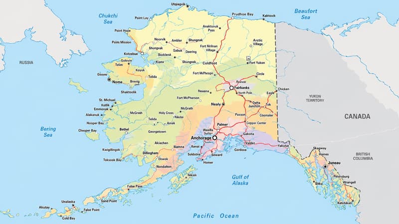
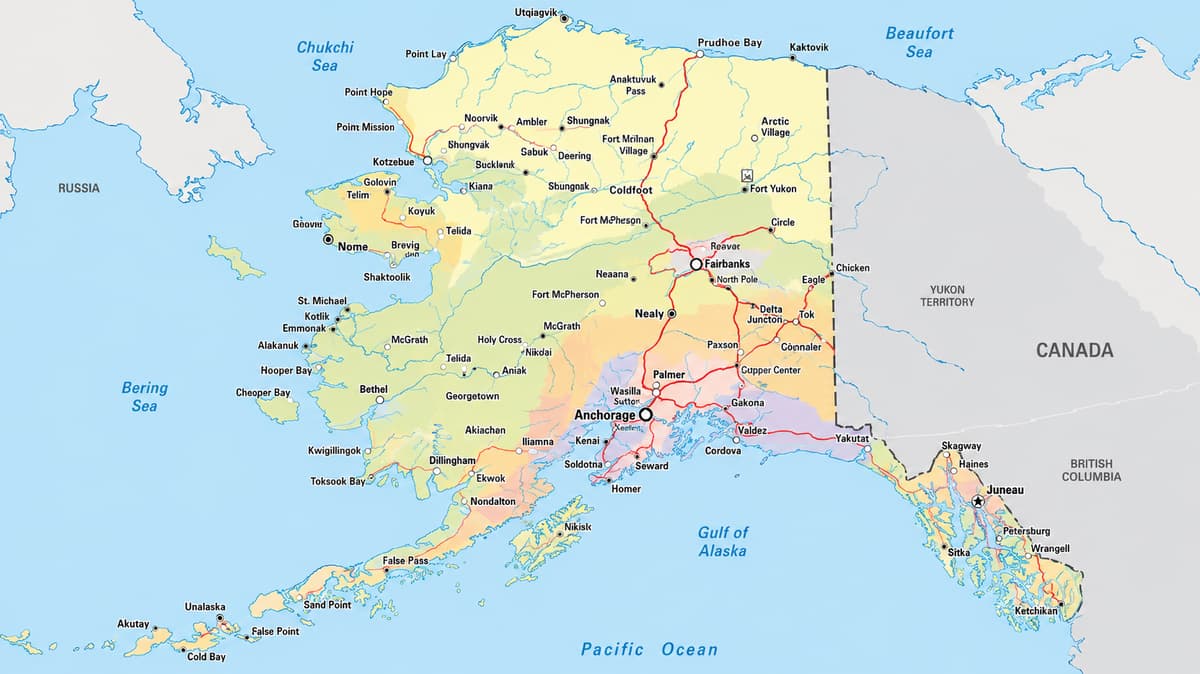
Description: Detailed large map of Alaska State, USA showing cities, towns, boroughs, census areas, and a light highway network for orientation.
Alaska is the only state bordered by just one country and no other U.S. state at all. Canada's Yukon and British Columbia run the entire eastern edge, while the Beaufort Sea, Chukchi Sea, Bering Sea, and Gulf of Alaska frame the rest. The map shows all 30 county-equivalents, 19 organized boroughs plus 11 census areas, with the Yukon, Kuskokwim, and Tanana rivers acting as the main orientation lines through the Interior. This is a map of Alaska cities first and a road map a distant second: Anchorage in South Central, Fairbanks in the Interior, and Juneau, the capital, tucked into the roadless Southeast Panhandle, are the only three real metro hubs the state has. Beyond those three, the map of Alaska major cities and towns thins out fast, since most communities have no road connection to anywhere and depend on small aircraft or the Alaska Marine Highway ferries to reach the outside world.
 Map of Alaska (USA). Alaska map with cities, boroughs, and towns. Use this detailed map to understand Alaska's full borough and census area grid, every borough seat and administrative hub, the major cities and towns, bordering territory and waters, and a few highway cues for orientation only. It is the best map style for residents, travelers, and geography students who want clarity without road clutter. Alaska organizes itself differently than the other 49 states: instead of counties, the state is divided into 19 organized boroughs plus the Unorganized Borough, which the Census Bureau splits into 11 census areas for statistical purposes since that huge remainder of the state, more than half of Alaska's land, has no borough government of its own. Together the 19 boroughs and 11 census areas add up to 30 county-equivalents, the units shaded and labeled on this map.
Borders and waters at a glance: Unlike every other state, Alaska touches no other U.S. state at all. Its entire land border runs along Yukon and British Columbia in Canada on the east side. Water frames the rest: the Beaufort Sea and Arctic Ocean to the north, the Chukchi Sea and Bering Sea to the west, and the Gulf of Alaska and Pacific Ocean to the south.
Road-light orientation: An Alaska map with counties and cities has to be honest about the roads: only a handful of highways connect a handful of places. The Seward Highway and Glenn Highway radiate out from Anchorage, the Parks Highway links Anchorage to Fairbanks by way of Denali, the Richardson Highway runs from Fairbanks to Valdez, and the Alaska Highway is the only road link to Canada and the Lower 48. Everywhere else on this map, from the Panhandle to the Aleutians, communities depend on air travel or the Alaska Marine Highway ferries rather than roads.
Alaska's only land neighbor is Canada: Yukon runs along the northern half of the eastern border and British Columbia along the southern half, meeting the Panhandle. No other U.S. state shares a boundary with Alaska at all. The map shows 19 organized boroughs and 11 census areas in the Unorganized Borough, 30 county-equivalents in total. In that sense, this map of Alaska counties, or more accurately boroughs and census areas, is really 30 separate stories stitched into one state. Yukon-Koyukuk Census Area is the largest by land area at roughly 145,576 square miles, bigger than Montana on its own, while Skagway Municipality is the smallest organized borough at about 434 square miles. The Municipality of Anchorage carries the most people of any borough, close to 291,000 residents, while Yakutat has the fewest at roughly 672. Ketchikan Gateway and Kodiak Island boroughs share the title of oldest, both organized in 1963 under Alaska's original Mandatory Borough Act. Alaska's capital is Juneau, reachable only by air or sea since no road connects it to the rest of the state, and its borough covers more land than Rhode Island and Delaware combined. Landscape-wise, the state runs from the icy Arctic coastal plain in the north, across the Brooks Range and Interior river basins, down through the volcanic Alaska Peninsula and Aleutian chain, and into the fjords and rainforest islands of the Panhandle in the south. Altogether Alaska covers about 665,384 square miles, the largest state by far, bigger than Texas, California, and Montana put together, yet home to only about 733,000 people, the third-fewest of any state. The ten largest cities by population are Anchorage, Fairbanks, Juneau, Wasilla, Sitka, Ketchikan, Kenai, Bethel, Palmer, and Kodiak.
Aleutians East Borough–Sand Point; Anchorage–Anchorage (consolidated city-borough); Bristol Bay Borough–Naknek; Denali Borough–Healy; Fairbanks North Star Borough–Fairbanks; Haines Borough–Haines; Juneau, City and Borough of–Juneau; Kenai Peninsula Borough–Soldotna; Ketchikan Gateway Borough–Ketchikan; Kodiak Island Borough–Kodiak; Lake and Peninsula Borough–King Salmon; Matanuska-Susitna Borough–Palmer; North Slope Borough–Utqiagvik; Northwest Arctic Borough–Kotzebue; Petersburg Borough–Petersburg; Sitka, City and Borough of–Sitka; Skagway Municipality–Skagway; Wrangell, City and Borough of–Wrangell; Yakutat, City and Borough of–Yakutat; Aleutians West Census Area–Unalaska; Bethel Census Area–Bethel; Chugach Census Area–Valdez; Copper River Census Area–Glennallen; Dillingham Census Area–Dillingham; Hoonah-Angoon Census Area–Hoonah; Kusilvak Census Area–Hooper Bay; Nome Census Area–Nome; Prince of Wales-Hyder Census Area–Craig; Southeast Fairbanks Census Area–Delta Junction; Yukon-Koyukuk Census Area–Fort Yukon. Census areas have no seat of government in the usual sense, so the second name in each pair marks the largest community for orientation instead.
On this map, the Alaska Range (anchored by Denali) and the Brooks Range double as landmarks for finding boroughs quickly, with the Yukon, Kuskokwim, and Tanana rivers acting as navigation lines through the Interior. For elevation, terrain, watersheds, and land-cover detail, see our Physical Map of Alaska.
Alaska's economy runs on a short list of big industries tied directly to geography. Oil and gas from the North Slope still move south through the Trans-Alaska Pipeline to the port at Valdez in Chugach Census Area, while commercial fishing fleets out of Kodiak, Dutch Harbor in Aleutians West Census Area, and the Bristol Bay sockeye runs keep Alaska among the top seafood-producing states in the country. Tourism concentrates heavily in the Panhandle, where cruise ships fill Juneau, Ketchikan, and Sitka each summer, and in the Interior around Denali National Park near Fairbanks North Star Borough. Military bases add another steady employer, especially Joint Base Elmendorf-Richardson in Anchorage and Fort Wainwright in Fairbanks. The map of Alaska major cities is short, and that brevity is the point: Anchorage alone holds close to 40 percent of the state's population, and the state's ten largest cities, Anchorage, Fairbanks, Juneau, Wasilla, Sitka, Ketchikan, Kenai, Bethel, Palmer, and Kodiak, together still add up to a small fraction of what a single mid-sized Lower 48 metro area holds. That is the story this map of Alaska cities and towns keeps telling: three real metro hubs, and hundreds of small, often roadless communities filling in everything around them.
Alaska Native cultures shape the map as much as any highway does. Inupiat and Yupik communities line the Arctic and Bering Sea coasts in North Slope Borough, Northwest Arctic Borough, Bethel Census Area, and Nome Census Area; Athabascan peoples are centered through the Interior along the Yukon and Tanana rivers; and Unangax (Aleut) communities anchor the Aleutians East Borough and Aleutians West Census Area chain. Southeast Alaska carries a different heritage entirely, home to the Tlingit, Haida, and Tsimshian nations, whose totem poles and clan houses are still a defining sight in Sitka, Ketchikan, and Wrangell. Gold Rush history runs through Skagway Municipality, once the gateway to the Klondike stampede of 1897 to 1898, and through Nome, which had its own gold rush a few years later. Every March, the Iditarod Trail Sled Dog Race retraces old mail and supply routes from Anchorage to Nome, cutting straight across several boroughs and census areas shown on this map. Higher education centers on the University of Alaska system, with campuses in Fairbanks (the system's oldest and a leading Arctic research university), Anchorage, and Juneau's Southeast campus.
Alaska's climate swings from Arctic tundra in the far north to subarctic across the Interior and a much milder maritime climate along the southern and southeastern coast. For a full seasonal and biome breakdown, see our Physical Map of Alaska.
Alaska's road network only touches a fraction of the state, and this map is honest about that rather than pretending otherwise. Around Anchorage, the Seward Highway runs south to the Kenai Peninsula and the Glenn Highway runs northeast into the Matanuska-Susitna Borough, while the Parks Highway connects Anchorage to Fairbanks by way of Denali, and the Richardson Highway continues from Fairbanks down to Valdez. The Alaska Highway is the only road link to the Lower 48, entering the state through the Interior via Canada's Yukon. None of Alaska's connecting corridors carry Interstate shields the way roads do in the other 49 states, even though a few are internally classified for federal highway funding purposes. Southeast Alaska, most of Southwest and Northern Alaska, and the vast majority of the Unorganized Borough have no road connection at all; the Alaska Marine Highway ferry system and small aircraft carry passengers, mail, and freight between those communities instead. One quick note on the map itself: ZIP codes in Alaska do not follow borough or census area lines, so use the shaded blocks on this map for jurisdiction, not a ZIP lookup.
The Municipality of Anchorage is Alaska's only true big city, a consolidated city-borough that alone holds close to 40 percent of the state's population and sits at the head of Cook Inlet between the Chugach Mountains and the water. It is the state's transportation, retail, and financial hub, and nearly every road-connected community in Alaska eventually routes through it. Just north, Matanuska-Susitna Borough, seat Palmer, fills the farming valley formed by the Matanuska and Susitna rivers, with Wasilla, Alaska's fourth-largest city, growing fast along the Parks Highway, and smaller communities like Houston and Talkeetna (the jumping-off point for Denali climbers) spread across the valley floor.
South of Anchorage, the Kenai Peninsula Borough, seat Soldotna, wraps around Kenai, the borough's largest city, and reaches down to Homer on Kachemak Bay and Seward at the head of Resurrection Bay, both popular gateways for fishing and glacier tours. East along the Gulf coast, the Chugach Census Area, centered on the port town of Valdez (the southern terminus of the Trans-Alaska Pipeline), also takes in Cordova and Whittier, communities tucked into fjords with little or no road connection to each other.
Northwest of Anchorage along the Parks Highway, Denali Borough, seat Healy, surrounds the entrance to Denali National Park and North America's tallest peak. East of Anchorage, the Copper River Census Area, centered on Glennallen, follows the Richardson Highway and the Copper River through wide, sparsely settled country toward the Wrangell Mountains and the Canadian border.
Alaska's capital, Juneau, is itself a City and Borough, and a large one: its roughly 2,700 square miles make it bigger than the state of Rhode Island, even though the city itself is squeezed onto a narrow shelf between the mountains and the Gastineau Channel. No road connects Juneau to the rest of Alaska; every visitor and most freight arrive by air or by the Alaska Marine Highway ferry. North along the Panhandle, Haines Borough, seat Haines, and Skagway Municipality both do connect by road, through the Alaska Highway system into Canada's Yukon, and Skagway's Gold Rush-era downtown still draws cruise passengers by the thousands each summer. The Hoonah-Angoon Census Area, spread across Hoonah, Angoon, and Gustavus near Glacier Bay, has no borough government and no connecting road either.
Sitka, a City and Borough on Baranof Island, was the capital of Russian Alaska before the United States purchased the territory in 1867, and it remains the largest city and borough in Alaska by land area. South along the Panhandle, Wrangell and Petersburg Borough both sit on protected waterways near the mouth of the Stikine River, the latter known for its strong Norwegian fishing heritage. Farther north and isolated from the rest of the Panhandle, Yakutat, a City and Borough on the Gulf of Alaska coast, is Alaska's least populous organized borough, reachable only by air or sea.
At the very southern tip of the state, Ketchikan Gateway Borough, seat Ketchikan, is often the first stop for cruise ships and ferries entering Alaska, known for its salmon canneries and totem pole collections. West across Clarence Strait, the Prince of Wales-Hyder Census Area, centered on Craig, covers Prince of Wales Island's logging and fishing communities along with the mainland outpost of Hyder near the British Columbia border.
Fairbanks North Star Borough, seat Fairbanks, is Alaska's second-largest population center and the Interior's hub, sitting in the Tanana Valley along the Parks and Richardson highways with the University of Alaska Fairbanks and Fort Wainwright anchoring the local economy. South of the city, North Pole keeps its holiday-themed name year-round. East along the Richardson and Alaska highways, the Southeast Fairbanks Census Area, centered on Delta Junction, marks the end of the Alaska Highway's long run up from Canada.
North and west of Fairbanks, the Yukon-Koyukuk Census Area is enormous, about 145,576 square miles, making it the largest county-equivalent anywhere in the United States, larger than the state of Montana on its own. It has no borough government and almost no roads; small communities like Fort Yukon, Galena, and McGrath sit along the Yukon and Kuskokwim river systems and depend on small aircraft for most travel and supplies.
Kodiak Island Borough, seat Kodiak, covers Kodiak Island and several smaller islands in the Gulf of Alaska, home to one of the country's busiest fishing ports and the Kodiak brown bear. West across Shelikof Strait, the Lake and Peninsula Borough, seat King Salmon, and the tiny Bristol Bay Borough, seat Naknek, sit at the heart of the world's largest sockeye salmon fishery, with no road connecting either to the rest of the state.
Southwest of the Alaska Peninsula, Aleutians East Borough, seat Sand Point, and the Aleutians West Census Area, centered on Unalaska and its port of Dutch Harbor, one of the busiest fishing ports in the country by volume, string out along the volcanic Aleutian Islands toward Russia. Every community here is reached only by boat or small plane.
North of Bristol Bay, the Dillingham Census Area, centered on Dillingham, and the Bethel Census Area, centered on Bethel, cover the wide, marshy Yukon-Kuskokwim Delta, home to dozens of small Yupik communities along river channels. West along the coast, the Kusilvak Census Area, centered on Hooper Bay, is one of the state's least developed census areas by most measures, with no road linking any of its villages to one another.
North Slope Borough, seat Utqiagvik (formerly Barrow), is Alaska's largest organized borough by land area at roughly 88,824 square miles, stretching from the Brooks Range crest to the Arctic Ocean coast. Utqiagvik is the northernmost community in the United States, and the borough's oil and gas revenue from the Prudhoe Bay fields funds services far beyond what its small population would otherwise support.
South of the North Slope, Northwest Arctic Borough, seat Kotzebue, sits above the Arctic Circle on Kotzebue Sound. Along the Bering Strait, the Nome Census Area, centered on Nome, the Gold Rush town made famous again each March as the finish line of the Iditarod, covers the Seward Peninsula and its scattered coastal villages, none connected to Nome or each other by road.
Three rivers do most of the orientation work on a map this size. The Yukon River crosses the entire Interior from the Canadian border to the Bering Sea, passing near Fort Yukon, Galena, and Nulato in Yukon-Koyukuk Census Area. The Kuskokwim River drains Southwest Alaska past Bethel on its way to Kuskokwim Bay. The Tanana River flows past Fairbanks before joining the Yukon farther west. Keep those three in mind, plus Cook Inlet at Anchorage and the Gulf of Alaska along the Panhandle, and almost any borough or census area on this map is easy to place.
The road layer here is intentionally minimal, and honestly, Alaska does not have much of one to show. The Seward Highway, Glenn Highway, and Parks Highway radiate out from Anchorage; the Richardson Highway and Alaska Highway connect Fairbanks to Valdez and to Canada. That is close to the entire connected network. None of it is meant for turn-by-turn navigation, only as a cue for where a handful of communities sit relative to each other. Everywhere else on this map, air travel and the Alaska Marine Highway ferries do the work that roads do in the other 49 states.
Residents can place their community inside a clear borough or census area frame and immediately see which neighbors and services sit nearby, something that matters more in Alaska than almost anywhere else, since the nearest hospital or grocery store might be a plane ride away rather than a drive. Travelers get a fast way to see which cities are actually connected by road and which require a ferry or flight, so a trip can be planned around reality instead of assumption. And geography students pick up Alaska's unusual 30-part structure quickly: 19 organized boroughs running their own governments, and 11 census areas covering the Unorganized Borough's huge remainder for statistics only. That is the clearest way to understand a map of Alaska with cities and towns spread across a state bigger than the next three largest states combined.
All 30: 19 organized boroughs plus 11 census areas in the Unorganized Borough.
Alaska's constitution set up boroughs instead. Large parts of the state stayed unorganized and were later split into census areas for statistics only.
The part of Alaska outside the 19 organized boroughs, over half the state's land, with no borough government of its own.
No. They exist only for Census statistics and mapping; the state handles services like law enforcement directly.
Juneau, inside the City and Borough of Juneau in Southeast Alaska.
Anchorage is its own consolidated city-borough, the Municipality of Anchorage.
Fairbanks North Star Borough.
Only Canada's Yukon and British Columbia. Alaska borders no other U.S. state.
The Beaufort and Chukchi seas and Arctic Ocean to the north, the Bering Sea to the west, and the Gulf of Alaska to the south.
The Seward, Glenn, Parks, and Richardson highways near Anchorage and Fairbanks, plus the Alaska Highway connecting to Canada.
No. Most of the state, including nearly all of Southeast and rural Alaska, has no road and relies on air or ferry travel.
In Matanuska-Susitna Borough, north of Anchorage along the Parks Highway.
A City and Borough on Baranof Island in Southeast Alaska, reachable only by air or ferry.
The seat of Ketchikan Gateway Borough at the southern tip of the Panhandle.
The seat of Kodiak Island Borough, on Kodiak Island in the Gulf of Alaska.
The seat of Bethel Census Area in the Yukon-Kuskokwim Delta of Southwest Alaska.
The seat of Nome Census Area on the Seward Peninsula, facing the Bering Sea.
The seat of North Slope Borough, the northernmost community in the United States.
The seat of Northwest Arctic Borough, above the Arctic Circle on Kotzebue Sound.
Both in Kenai Peninsula Borough; Soldotna is the borough seat and Kenai is the largest city.
The seat of Matanuska-Susitna Borough, in the farming valley northeast of Anchorage.
Yukon-Koyukuk Census Area, about 145,576 square miles, the largest county-equivalent in the United States.
Skagway Municipality, at about 434 square miles.
The Municipality of Anchorage, with roughly 291,000 residents.
Yakutat, with roughly 672 residents.
Anchorage, with roughly 291,000 residents, nearly 40 percent of the state's population.
Ketchikan Gateway and Kodiak Island boroughs, both organized in 1963 under Alaska's original Mandatory Borough Act.
About 665,384 square miles total, the largest state by far, bigger than Texas, California, and Montana combined.
No. This map focuses on boroughs, census areas, cities, and towns; ZIP boundaries do not always match those lines.
No. Printing or copying our maps from this site is not permitted.

Physical Map of Alaska
Physical map and map image of Alaska.

Regional Directory of Canada
Information and guide about Canada and website listing.

Regional Directory of United States of America
Information and guide about United States of America and websites with American topics.

Regional Directory of Europe
Information and guide about Europe and websites with European topics.

Regional Directory of Australia
Information and guide about Australia and websites with Australian topics.
