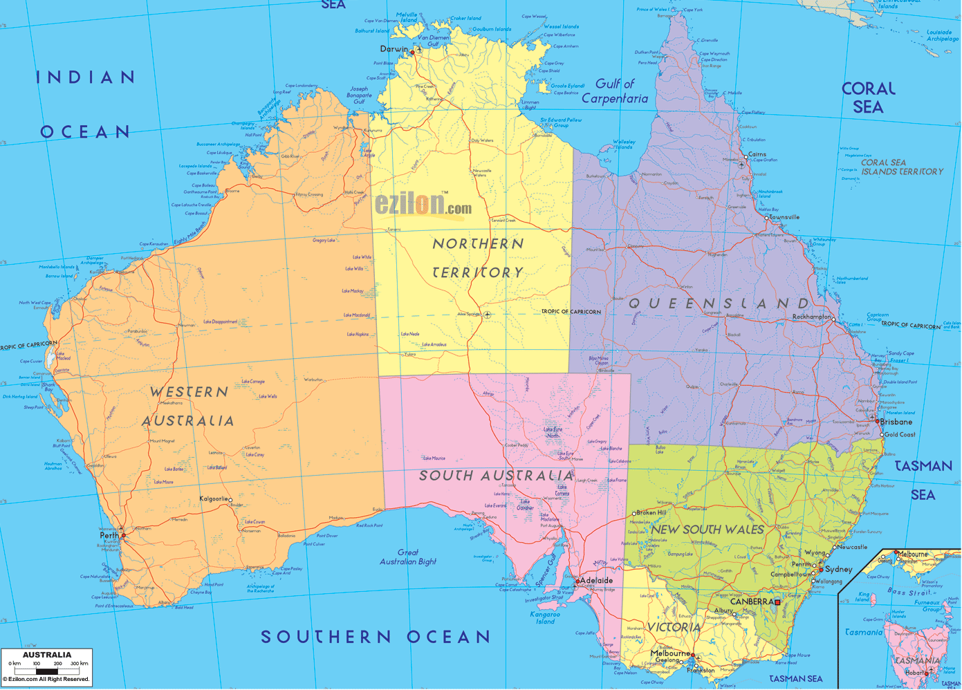
Description: Detailed large political map of Australia showing names of capital city, towns, states, provinces and boundaries with neighbouring countries.
The map of Australia in front of you, which shows you the states, cities, and towns, is a political map. This is a detailed map that clearly colors the continent into states and territories, names the capitals and major cities, and shows how towns and small communities are positioned along coastlines and inland corridors.
The political map of Australia is one of the best map types, allowing one to see how Australia is organized and how its population is distributed. The map features the political boundary lines, city names, state labels, and sea names rather than the physical features.
According to the map of Australia, the country comprises six states and two main mainland territories. The states comprise New South Wales, Victoria, Queensland, South Australia, Western Australia, and Tasmania, whilst the mainland territories are the Northern Territory and the Australian Capital Territory (ACT). Each State or territory in the map is a different color. The borders of each region are drawn so clearly that it is easy to delineate each area from the next.
Examples of capital cities which are recorded on the notes are Canberra, the national capital in the ACT, Sydney, for New South Wales, Melbourne, for Victoria, Brisbane, for Queensland, Adelaide, for South Australia, Perth, for Western Australia, Hobart, for Tasmania, Darwin, for the Northern Territory.
Smaller but still prominent labels denote other major cities and large towns, including Gold Coast, Newcastle, Wollongong, Townsville, Cairns, Geelong, Launceston, and Alice Springs, on the Australia map.
The map of Australia with cities and regions also pinpoints the Indian, Southern, and Pacific Oceans, as well as Indonesia, Papua New Guinea, and New Zealand. The Indian Ocean lies to the west, south, and southeast of the continent.
When you start from the southeast with the Map of Australia with towns and villages, you will come across New South Wales (NSW) in different colors, occupying a large part of the eastern seaboard. Located on the central east coast, Sydney - the nation's capital - is one of the largest cities and a major gateway for incoming international flights.
The map shows coastal regions north and south of Sydney, including Newcastle, Wollongong, Coffs Harbor, and Port Macquarie. Towns like Tamworth, Dubbo, Wagga Wagga, and Albury are located further inland on the road to Queensland, Victoria & South Australia.
People driving from Sydney to Brisbane or Melbourne, or hoping to explore the inland farm country, will find the Australia map cities layer very useful, which includes coastal and inland cities. The border of the State with Queensland to the north, Victoria to the south, and South Australia to the west is easy to follow. As such, it provides residents and travelers with an indication of where NSW fits within Australia and its regions.
Victoria is a state of Australia that has cities and towns. Moreover, the map of Australia shows that it is in the south of New South Wales. Melbourne, the capital, is situated on the northern shore of Port Phillip Bay and is one of the largest cities. The map features significant regional centers in Victoria, such as Geelong, Ballarat, Bendigo, Shepparton, and Mildura, all with a city symbol and name.
Victoria's borders lie north of New South Wales and west of South Australia, as indicated on the map by major road routes. These connections to Melbourne and regional towns give a sense of how people move between Melbourne and neighboring states. Residents and geography students will appreciate this map of Australian cities, which shows the concentration in the southeast corner of the continent.
Moving north along Australia's east coast, the map shows that Queensland is a large state that extends from subtropical latitudes into the tropics. Brisbane, the capital, is located in the south near the coast, while coastal cities such as the Gold Coast, Sunshine Coast, and Bundaberg are located along the coast. Further up the coastline, the map depicts the regional centers of Rockhampton, Mackay, Townsville, and Cairns, indicating the chain of settlements along the Queensland coast.
The map also shows interior towns, including Toowoomba, Mount Isa, Longreach, and Charleville, indicating how far settlements penetrated inland. The Australia map with cities shows the borders of the states of New South Wales, South Australia, and the Northern Territory. It labels the Coral Sea and the South Pacific Ocean off the coast to better understand Queensland's location.
Located in central southern Australia, South Australia occupies a broadly wedge-shaped expanse that faces the Southern Ocean. The southeastern corner of the State of Australia is shown, with the capital, Adelaide, and the coastal setting. Smaller dots on the map, along the coast and on inland highways, represent other cities and towns, such as Port Augusta, Whyalla, Port Lincoln, Mount Gambier, and Port Pirie.
The map shows South Australia's borders: Western Australia to the west, the Northern Territory to the north, and Queensland, New South Wales, and Victoria to the east. Traveling cross-country is much easier with the Australia map showing cities and regions, as the long transcontinental routes clearly explain how Adelaide connects with Perth, Melbourne, Alice Springs, and Brisbane.
The Map of Australia with regions devotes a large area to Western Australia (WA), the biggest State in Area, to the west. Both the Indian Ocean and the city of Perth are identified. Perth is the capital of the Australian State of Western Australia. Perth is on the south-west coast. Towns and cities on the coast, such as Fremantle, Bunbury, Geraldton, and Albany, also seem to appear, showing how many people in WA live right by the coast.
Further up north, the map indicates spots like Karratha, Port Hedland, and Broome set far apart mostly along the coastline, while the inland names of Kalgoorlie and Newman appear along the transport routes. On the western side of the Australia map, with cities and towns, is the Indian Ocean. The international context afforded by Indonesia to the north helps users see how Western Australia is positioned as the country's gateway to the Indian Ocean rim.
The map of Australia shows the Northern Territory (NT), a large territory in north-central Australia between Western Australia and Queensland. The city of Darwin is marked on the north coast, designated as the chief town and port of the Timor Sea.
Further to the south, Alice Springs is located approximately at the center of the continent. It functions as the service center for remote inland Australian communities. Towns like Katherine, Tennant Creek, and Nhulunbuy indicate the relatively large distances between settlements, as shown by the small dots along major routes. Australia is home to various territories and provinces.
Though the NT region has a small population, it still has several important cities and a robust infrastructure. Similarly, the NT section of the Australia map with cities shows a territory with a relatively small population may still have important administrative centers. These cities connect the northern ports with the inland desert corridors. Similarly, these geography maps have great educational value for students.
Tasmania, located off the southeastern coast of mainland Australia, is an Australian state and appears on the map with cities and regions. The capital Hobart is located on the southern coast. Readers can quickly identify the island's population centers, as indications are provided for other towns such as Launceston, Devonport, and Burnie.
The Australian Capital Territory (ACT) is located on the mainland between Sydney and Melbourne. The map shows the ACT as a small highlighted area around Canberra, the national capital. Students learn from maps of Australian cities that Canberra lies between Sydney and Melbourne. The special symbol and strong font used on the map for this city make it easy to remember this relationship.
In this second part, you can think of tracing the edge of the map of Australia. You could run your finger in an anticlockwise direction. Along the way, you would pass various cities and towns around the continent, starting at Sydney.
From Sydney, you can trace the road dots leading south to Canberra and then to Albury and Melbourne, onwards to Geelong and Portland, and see the links between New South Wales and Victoria. Moving westwards along the coast, the lines on the map join at Mount Gambier, and at Adelaide, then head out across the long southern coastline and on to Ceduna, Eucla, and Norseman, before Perth and the south-west corner of Western Australia.
The line of settlements on the Australia map, from Perth northwards along the Indian Ocean, shows Geraldton, Carnarvon, Karratha, Port Hedland, and Broome. From cosmopolitan ports to sleepy fishing harbors, these coastal towns are the link between long stretches of uninhabited coast.
The course eventually heads east through the Northern Territory, passing through Kununurra, Katherine, and Darwin, paying its way south through Tennant Creek and Alice Springs before retracing its steps eastwards towards Mount Isa, Townsville, and Cairns in Queensland.
The map of Australia with cities and regions also shows surrounding seas and neighboring countries, which is quite helpful for understanding the country's geopolitics. To the northwest are the Indian Ocean and the maritime borders with both Indonesia and East Timor.
In the northeast direction of the map above, the Arafura Sea, Coral Sea, and Torres Strait are noted. The map shows the Tasman Sea and the Pacific Ocean to the east of New Zealand. To the south, the Southern Ocean surrounds Tasmania and the southern mainland.
The mapping of Australia helps residents and students better understand the country's role in Oceania and the broader Indo-Pacific region. This, in turn, is important for trade, migration, and climate. Users checking a map of Australia with towns are also supported in trip planning as they contemplate routes that may involve international flights or a cruise to neighboring countries.
This is an educational political Map of Australia with towns and villages. It includes a legend, source text, scale, and a north arrow. The biggest icons include Canberra, which is the national capital, and the capitals of the states: Sydney, Melbourne, Brisbane, Adelaide, Perth, Hobart, and Darwin. Other major cities and regional centers, such as Gold Coast, Newcastle, Wollongong, Townsville, Cairns, Geelong, and Launceston, are marked with slightly smaller symbols.
The smaller dots represent country towns and smaller communities. You can see that most Australian settlements hug the coastline, with the interior of the country having far fewer towns. According to geographers, a handy visual lesson on where people live, and travelers can get an ordering of where, in the world, they are likely to find a place with a service, airport, train station, regional hospital, etc.
This Map of Australia with cities and towns connects states, territories, cities, towns, borders, and seas; hence, it's useful for most kinds of users. You would use it to check which State you are in, which is your State capital, and which major centers you can reach by car, for example, from Sydney, Newcastle, and Wollongong; from Melbourne, Ballarat; and from Brisbane, Rockhampton.
People can outline their cross-country journey between major cities via a string of towns, e.g., from Perth to Adelaide via the Nullarbor, from Adelaide to Darwin via Alice Springs, and from Brisbane to Cairns via the Queensland coast.
The map of Australia with regions is an informative piece that contains a lot of information about the federation for geography students. It shows how six states and two major territories span the entire continent, and where the national capital is located in the ACT.
Moreover, state capital towns are mainly located right on the coast. Because this political map lacks physical features, learners can focus on state boundaries, town locations, population, and related topics in human geography. Extra layers, however, may be added, like climate or landform.
Australia is located in the Southern Hemisphere between the Indian and Pacific Oceans.
The map shows six states and two main mainland territories of Australia.
The states shown are New South Wales, Victoria, Queensland, South Australia, Western Australia, and Tasmania.
The map shows the Northern Territory and the Australian Capital Territory.
Canberra is shown as the national capital in the Australian Capital Territory.
Major cities shown include Sydney, Melbourne, Brisbane, Perth, Adelaide, Hobart, Darwin, and Canberra.
Sydney is located on the southeastern coast of Australia in New South Wales.
Cities near Sydney include Newcastle, Wollongong, Coffs Harbour, and Port Macquarie.
Melbourne is located in southeastern Australia on Port Phillip Bay in Victoria.
Regional Victorian cities shown include Geelong, Ballarat, Bendigo, Mildura, and Shepparton.
Brisbane is located on the southeastern coast of Queensland.
Queensland coastal cities shown include Gold Coast, Sunshine Coast, Bundaberg, Mackay, Townsville, and Cairns.
Inland Queensland towns shown include Toowoomba, Mount Isa, Longreach, and Charleville.
Adelaide is located in South Australia along the Southern Ocean coastline.
South Australian towns shown include Port Augusta, Whyalla, Port Lincoln, Mount Gambier, and Port Pirie.
Perth is located on the southwestern coast of Western Australia beside the Indian Ocean.
Western Australian towns shown include Fremantle, Bunbury, Geraldton, Albany, Kalgoorlie, Broome, and Port Hedland.
Darwin is located on the northern coast of Australia in the Northern Territory.
Northern Territory towns shown include Alice Springs, Katherine, Tennant Creek, and Nhulunbuy.
Tasmania is located south of mainland Australia across Bass Strait.
Tasmanian cities shown include Hobart, Launceston, Devonport, and Burnie.
The ACT is located inland between Sydney and Melbourne in southeastern Australia.
The map shows the Indian Ocean, Pacific Ocean, Southern Ocean, Coral Sea, Tasman Sea, and Arafura Sea.
Neighboring countries shown include Indonesia, Papua New Guinea, New Zealand, and East Timor.
The map shows light transport corridors linking Sydney, Melbourne, Adelaide, Perth, Darwin, Brisbane, and Cairns.
Yes, the map clearly displays state and territory boundaries across Australia.
Yes, the map is useful for studying states, territories, cities, borders, and population distribution.
Yes, travelers can use the map to understand interstate routes, coastal cities, and regional travel corridors.
Most Australian cities are near the coast because the interior has fewer settlements and harsher environmental conditions.
No. Printing or copying maps from this site is not permitted.

Physical Map of Australia
Physical map and map image of Australia.

Regional Directory of Australia
Information and guide about Australia and website listing.

Regional Directory of United States of America
Information and guide about United States of America and websites with American topics.

Regional Directory of Europe
Information and guide about Europe and websites with European topics.

Regional Directory of Australia
Information and guide about Australia and websites with Australian topics.