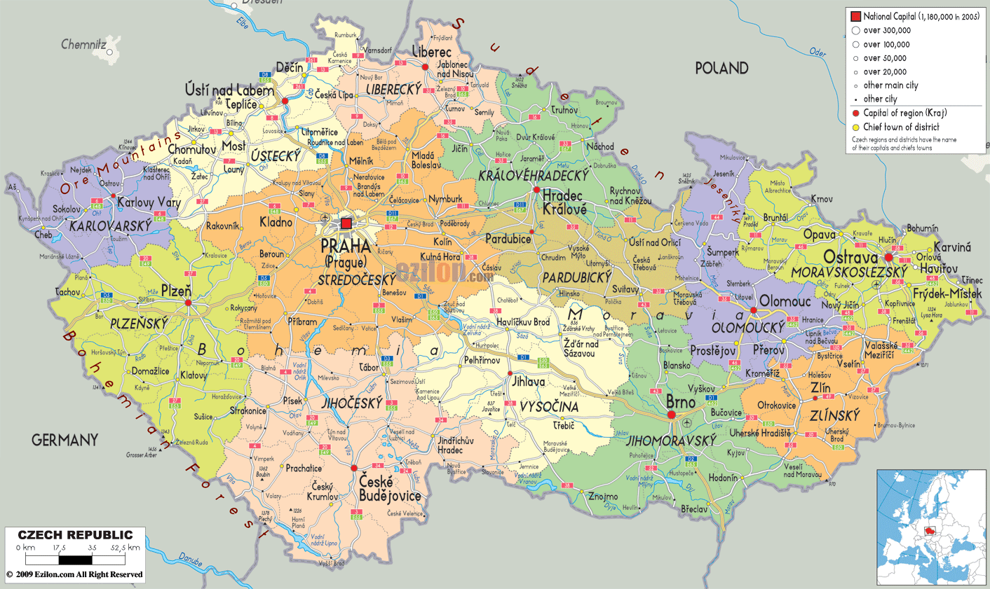
Description: Detailed large political map of Czech Republic showing names of capital cities, towns, states, provinces and boundaries with neighbouring countries.

The map of the Czech Republic (Czechia), showing cities, towns, and regions, illustrates the country's political layout. A detailed map of Czechia depicts a small Central European state bordered by Germany (west), Poland (north), Slovakia (east), and Austria (south). We can see the internal line showing the 14 districts. A map of Czechia can also show other cities and villages within the state.
One of the best Czech Republic map formats for understanding the country's political organization for government, business, and travel, this map representation focuses on borders, regional names and capitals, and transport routes.
The Czech Republic is a landlocked Central European country with hilly to mountainous terrain. Its adjacent countries are Germany, Poland, Austria, and Hungary. The map of the Czech Republic with regions shows the capital city, Prague,, at the center of the country. Further, Prague is surrounded by regions including Central Bohemia, South Bohemia, Pilsen, Karlovy Vary, Usti nad Labem, Liberec, Hradec Kralove, Pardubice, Vysocina, South Moravia, Olomouc, Zlin, and Moravian Silesia. Also, most of these regions on the map of the Czech Republic are shaded in a different color.
The Czech Republic map labels cities and towns and, in color, shows urban public places, including Brno, Ostrava, Plzen, Liberec, Olomouc, Ceske Budejovice, Hradec Kralove, Pardubice, Zlin, and Jihlava. Besides, there are dozens of smaller towns that together create a dense settlement pattern in this country.
The map of the Czech Republic includes a friendly legend explaining the symbols for the national capital, regional capitals, other major cities, and small towns, so the reader can take in the map at a glance.
The regions of Usti nad Labem and Karlovy Vary are located next to each other near the upper left side of the map of the Czech Republic, with city and regional borders in Europe. According to the map, Usti nad Labem is considered a regional capital on an important north-south route. Other cities, such as Most, Teplice, Decin, and Chomutov, are marked with smaller circles. The Karlovy Vary Region is west of Karlovy Vary, home to the capital, Karlovy Vary, and the towns of Cheb and Sokolov, located near the German border.
The Czech Republic map’s cities layer marks how Czechia connects by road and rail links, shown on our map, the economic centers of Germany - Dresden and Chemnitz, which are marked in the northwestern region. They also show how the country’s political borders follow the crest of the Ore Mountains without depicting terrain, while limiting depictions of training towns and the political assignment of border towns.
The Plzeň Region lies in the western interior of the Czech Republic and extends southward into the Plzeň Region. Pilsen is a major city and the region’s capital. Other settlements in the region, like Klatovy, Domazlice, and Rokycany, are demarcated with less prominent circles that spread between Plzen and the German border to the west, as well as along the road corridors leading towards Prague in the east. In the map below, Plzeň, we begin to see the northern edge of the South Bohemian Region, which we will explore more fully in our travels through the southern part of the country.
On the political map of the Czech Republic above, which features cities and towns, Prague is marked with a special symbol indicating that it is not only the national capital but also a region. The Central Bohemian Region surrounding it is shaded separately. This ring city usually includes Kladno, Mladá Boleslav, Kolín, and Příbram, as shown in the Czech Republic cities layer. Prague is the center of major roadways feeding directly into all regional capitals. Whether looking at a map or disregarding waterways and relief, they stand out quite clearly.
This central cluster for residents and students shows how Prague serves as Czechia’s administrative and transportation hub. In particular, the map of the Czech Republic, which contains Czechia’s cities and regions, provides relevant information for national planning and the study of commuting flows.
The north and northeast of Prague are closely linked, as shown on our map. The Liberec Region lies on the borders of Poland and Germany. Liberec is the capital, while nearby towns include Jablonec nad Nisou and Ceska Lipa.
To the east, the Hradec Králové Region shows Hradec Králové as the regional capital. And the neighboring Pardubice Region shows Pardubice as the regional capital. These two regional capitals are close to each other on the map and are connected by several route symbols.
The Czech Republic map shows that the towns in the midlands, along with the region's villages, form a corridor between Prague and the Polish border. In addition, the mid-sized towns are arranged along transport ways like beads on a string.
The Vysocina Region is located in the central southeast part of the country. It lies in the hilly region between Bohemia and Moravia. According to the map of the Czech Republic, Jihlava is the capital of this region. Trebic, Zdar nad Sazavou, and Havlickuv Brod are marked as smaller centers. The map shows that to the south of Vysocina, the South Moravian Region will dominate. Its capital city, Brno, is indicated with a large circle and bold text.
The map of the Czech Republic is no doubt a better travel companion, especially in the areas around Brno, where it has city or town labels, such as Znojmo, Brno, Hodonín, and Blansko. The metropolitan area extends along corridors towards the Austrian and Slovakian borders.
Travelers will find this map section useful. It is clear that travelers departing from Prague to Brno will pass through the regional center of Jihlava. It is also clear that you can branch off towards Vienna, Bratislava, and the wine-growing parts of southern Moravia.
Further east on the map of the Czech Republic, the Olomouc and Zlin Regions occupy central Moravia. Olomouc is the regional capital in the north, marking towns such as Přerov and Sumperk. Further southeast, Zlin, the capital of its region, is marked, along with Uherske Hradiste and Kromeriz, on a small scale. The smaller version of Zlin (2) can also be read.
The main roads linking the cities appear to run east-west across the map, indicating that central Moravia serves as a bridge between Brno and the far eastern Moravian Silesian Region.
The easternmost region of the Czech Republic on the map above, the Moravian-Silesian Region, borders Poland and Slovakia. The map shows Ostrava, the regional capital and Czechia’s third-largest city, with a large symbol, and marks the industrial towns of Karvina, Opava, Havířov, and Frýdek-Místek with small circles. Ostrava, located in the Czech Republic, serves as an important hub for the region’s road and rail transport system. As is evident from our political map, roads and railways emanate from Ostrava towards Katowice, Poland, and Zilina, Slovakia. This also reveals cross-border connections without needing physical details.
From a regional planning perspective, the eastern corner of the Czech Republic’s map, with its towns and villages, illustrates how the heavy industry and mining belt of Czechia connects to neighboring countries and serves as an important reference for economic geographers and logistics studies.
The south-western part of Bohemia, on our detailed map, is occupied by the South Bohemian Region. The regional capital, Ceske Budejovice, is located at the center of the region, while Tabor, Pisek, and Cesky Krumlov are shown as smaller towns near the Austrian border. The Czech Republic Map with Cities and Regions details the region through which the main road south from Prague passes, which connects border crossings to Austria and cities like Linz.
Use the Czech Republic map with cities and towns to discover the distribution of towns in South Bohemia. You will see that historic centers and border towns are quite close to each other. This enables you to take day trips across the Czech Republic and Austria with ease.
An overview of the Czech Republic on a map with cities and towns may start at the western border near Cheb and Karlovy Vary, move east to Plzen, and finally reach the center, Prague, the national capital.
The Czech Republic map cities layer allows the eyes to follow routes north to Usti nad Labem and Liberec, east to Hradec Kralove and Pardubice, south to Ceske Budejovice, and southeast to Jihlava, Brno, Olomouc, and Ostrava at the far end of the country.
One more visual route in Czech Republic with regions follows the edge of the border on our map, starting on the German border in the west and continuing clockwise: through Karlovy Vary and Usti nad Labem, along the Polish border not far from Liberec and Ostrava, down the Slovak border near Zlin and the South Moravian wine districts, and so along the Austrian border through Breclav, Znojmo and Ceske Budejovice before returning again to the west. This loop demonstrates how Czechia's political borders and regional capitals form a continuous frame for the internal network of Czech cities and towns.
The map of the Czech Republic clearly shows the country's position in Central Europe by indicating the names of each neighboring country along its borders. It is labeled as Germany in the west and northwest; Poland in the north and northeast; Slovakia in the east; and Austria in the south.
Road signs clearly indicate important border crossings to Dresden, Nuremberg, Vienna, Bratislava, and Krakow, though they do not mark the borders themselves. Moreover, the focus is on the Czech side.
Travelers creating a multi-city itinerary will find this map of the Czech Republic, showing cities, towns, and their borders, useful. You can easily see how easy it is to base yourself in Czechia with Prague and Brno, and also include other capitals such as Vienna and Bratislava. Students of geography benefit from seeing how a landlocked state like Czechia depends on its neighbors to get access to seaports. They also gain insight into broader European transport corridors without the need for physical relief on the map.
The Map of the Czech Republic with towns and villages is like other good maps. It employs differently sized symbols and fonts, which helps to demonstrate the hierarchy of the settlements. The largest symbol and the most conspicuous label identify Prague as the capital and the largest city, while major regional capitals use a somewhat smaller but still prominent circle. Brno, Ostrava, Plzeň, Liberec, Olomouc, and Česká Budejovice.
Midsized towns and important district centers are denoted by medium dots with easily readable labels, while smaller towns are shown by a fine point or name. Thus, the area is filled with towns and villages.
It’s vital for residents choosing where to access services, such as hospitals and universities, as well as major shopping areas. They can immediately see which city on the map is closest to their town. For visitors, it shows which towns deserve a visit and which smaller cities make good day trips from major bases like Prague or Brno.
Because this map shows administrative regions, cities, towns, borders, and road links, it is helpful in many contexts. Roaming the platform, visitors can easily find the municipality where they live in one of the 14 regions, the location of the regional capital, and the roads leading to the capital, large enough for work, studies, or government services.
Travelers can use a map of the Czech Republic with cities, along with a link to a map showing routes to connect Prague, Plzen, Ceske Budejovice, Brno, Olomouc, and Ostrava in that order, with side trips to spa towns like Karlovy Vary or historic centers like Cesky Krumlov.
The map of the Czech Republic with regions is a useful case study for geography students. This is a landlocked Central European state divided into 14 self-governing regions and the capital city, illustrating how political and administrative boundaries operate. The boundaries also coincide with the historical regions of Bohemia, Moravia, and Czech Silesia.
The omission of mountains, rivers, and other physical features from the map means learners can first engage with human geography topics like regional administration, urban networks, and border relations before placing physical maps on top for an ultimately environmental reading.

Physical Map of Czech Republic
Physical map and map image of Czech Republic.

Road Map of Czech Republic
Road map and map image of Czech Republic.

Regional Directory of United States of America
Information and guide about United States of America and websites with American topics.

Regional Directory of Europe
Information and guide about Europe and websites with European topics.

Regional Directory of Australia
Information and guide about Australia and websites with Australian topics.