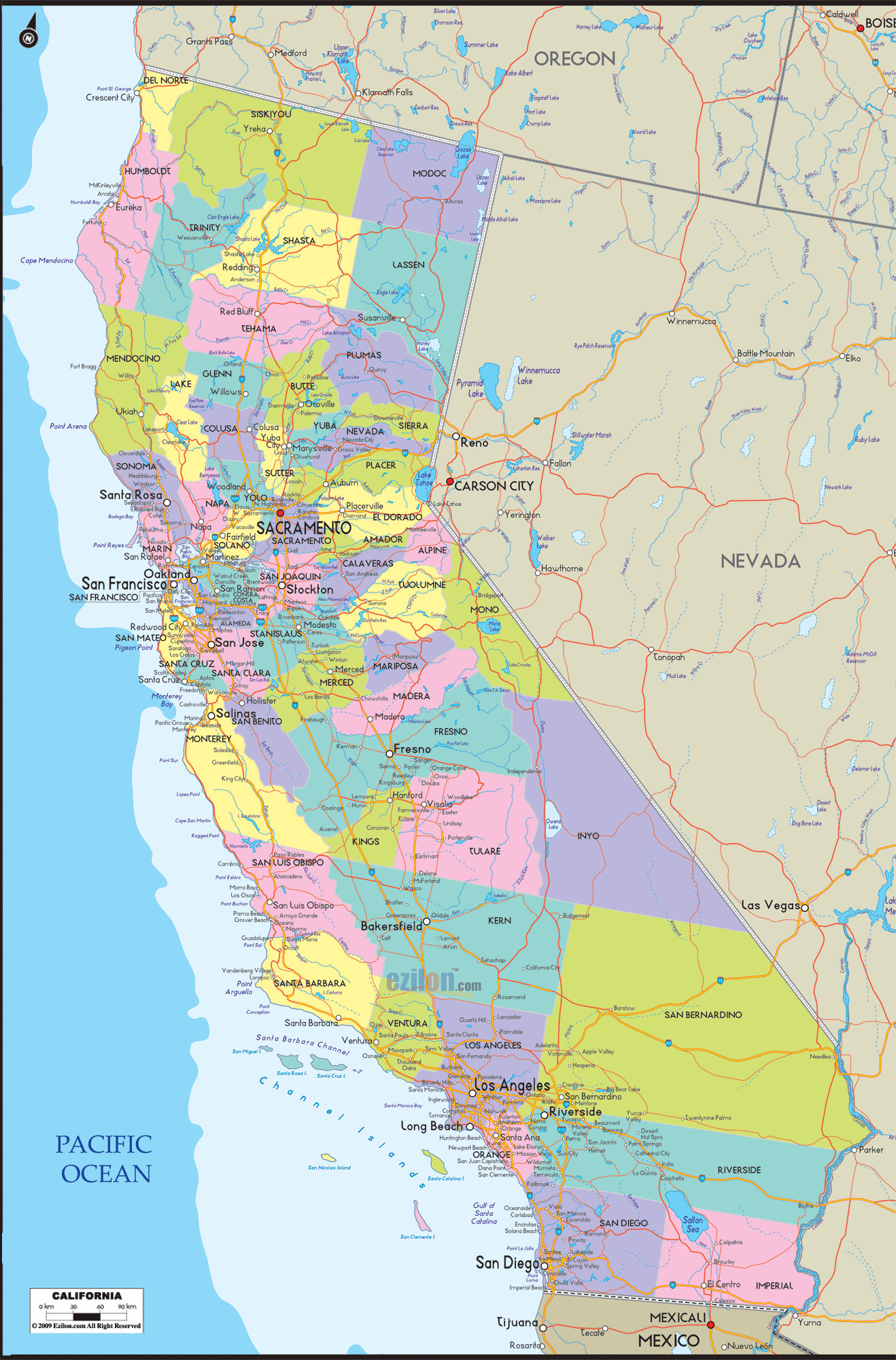

Description: Detailed large map of California showing cities, towns, counties, roads, US highways and State routes.
 When you first look at our large, detailed map of California cities and roads, you'll instantly notice its intricate design, which goes above and beyond to encapsulate the multi-dimensional political landscape of the state. This map isn't merely a smattering of lines and names; it serves as an exhaustive visual document that aids in comprehending the diverse geographic and roads complexity of California.
The map uniquely portrays cities from Eureka to San Diego, towns from Oxnard to Chico, and counties from Plumas to Imperial. Whether you are a student diving into an in-depth research project about California's cities and roads. Possibly, an adventurous traveler mapping out a wide-ranging tour of the state, or a curious individual who wants to understand the lay of the land, this map is a resource that you may use.
Starting our geographical and tour in the North, you'll come across sparsely populated yet significant counties such as Del Norte, Siskiyou, and Modoc, each prominently displayed on the map. Aside from substantial centers like Redding in Shasta County, you'll also find towns like Crescent City, Yreka, and Alturas.
These areas offer stunning natural vistas and serve as the setting for local governance, each with unique issues from forestry to fishing rights, all with broader implications at the state level. The map, therefore, guides understanding how these counties interact with the rest of California politically.
Moving southward, the Bay Area, the epicenter of technological innovation, culture, and political discourse, is prominently showcased. You will find well-known cities like San Francisco, Oakland, and San Jose and smaller yet politically active towns like Palo Alto, Mountain View, and Berkeley here. Marin County is a rich and beautiful next to cities like Alameda and Contra Costa.
Further inland, you have Solano and Napa counties, each with its distinct political atmosphere. Issues here range from housing affordability in San Mateo County to debates on privacy laws emanating from the headquarters of major tech companies in Santa Clara County.
As we delve into Central California, the map highlights several counties. Aside from larger counties like Fresno and Kern, we also see Merced, Stanislaus, and San Joaquin, home to cities like Modesto, Merced, and Stockton.
It is the heart of California's agricultural region, with issues such as water rights, land use, and migrant labor being major political talking points. Smaller towns like Turlock and Clovis also contribute to the local political discourse, often echoing more significant statewide concerns but with a local twist.
The map gets bigger and shows more information about Southern California when you go down toward the south. Los Angeles County, containing cities like Glendale, Santa Monica, and Pasadena, to its surrounding counties like Ventura, Orange, and San Diego.
The map highlights cities like Santa Ana in Orange County and Oceanside in San Diego County, which grapple with issues as varied as immigration reform and environmental sustainability. The Inland Empire, represented by Riverside and San Bernardino counties, brings into focus cities like Riverside, Moreno Valley, and Ontario, each with its challenges, from industrial development to air quality concerns.
Glancing towards the eastern edge of the map, you'll notice counties like Mono, Inyo, and Imperial. These areas feature towns such as Mammoth Lakes in Mono County and Calexico in Imperial County.
The map serves as a reminder that these regions deal with distinct challenges related to land conservation, natural resources, and proximity to border states like Nevada and Arizona. The political discourse here often revolves around land management, water scarcity, and border security.
The western axis of the map offers an extensive portrayal of California's coastline, marking towns like Malibu, Santa Cruz, and Monterey. This area is especially significant due to maritime policies, naval bases in cities like Coronado, and tourism in places like Carmel-by-the-Sea.
You'll notice how different these coastal towns are from one another, each with its unique set of local rules, from beach access laws in Orange County to conservation efforts in the less developed parts of the Northern Coast.
The Large Detailed Political Map of California is an indispensable reference guide transcending mere geography. It encapsulates the vast realities that define the Golden State, from the bustling corridors of Sacramento to quieter, yet no less significant, locales like San Luis Obispo or Eureka.
This map is your ticket to an in-depth understanding of California, presenting a detailed and nuanced view that invites you to explore the state's landscape. It comprehensively covers California's 58 counties, numerous cities, and countless towns.
Whether planning a road trip, preparing an academic paper, or being involved in policy analysis, this map is your ultimate guide to understanding California's intricate geography.
Navigating California's extensive network of roads can seem overwhelming, but our Comprehensive Road Map of California offers an easy-to-understand, highly detailed guide to the state's complicated roadways.
It is not just a series of lines and symbols; it's an in-depth resource meant to provide you with the most comprehensive and current data on California's interstates, highways, main roads, and back roads. The map illustrates the interconnectivity between different regions within the state and surrounding states.
This map is your key to understanding the transportation web that links California's numerous cities and towns while tying the state into the more extensive transcontinental network.
The map opens up with a detailed representation of Northern California's road network, prominently featuring the critical artery of Interstate 5 (I-5), which runs from the Oregon border southward through Redding, Sacramento, and Los Angeles. Other important roads in the North include US Highway 101, which serves coastal cities like Crescent City and Eureka, connecting them to the San Francisco Bay Area.
The northern region also offers direct routes to Nevada via I-80, which passes through bustling cities like Sacramento and quiet towns like Truckee before entering the neighboring state. Roads such as CA-299 and US-395 provide additional connections, especially to rural and scenic areas, serving as your direct routes to destinations like Mt. Shasta, Lake Tahoe, and the extensive forests of the Pacific Northwest.
Moving towards the center, you'll see the maze of roads that serve the Bay Area, with critical routes like I-880, I-680, and US-101. These roads link the bustling cities of San Francisco, Oakland, and San Jose and connect the area to the broader region. The map also features the Central Valley, often called the "Breadbasket of the World," which is served by various roads parallel to I-5, such as CA-99 and CA-41.
These roads link key agricultural cities like Fresno, Bakersfield, and Modesto. A network of more minor roads and state highways connects these urban centers to countless more diminutive towns and farmlands, highlighting their role in feeding the state and the nation. Routes like CA-152 and CA-46 provide crucial east-west links, offering ways to cross the coastal mountain ranges.
In Southern California, the map highlights the intricate lattice of freeways that spread out from Los Angeles, a testimony to the city's car-centric culture. Major interstates like I-10, I-405, and I-110 are well-marked, guiding you through the sprawling metropolitan area and beyond to cities like Palm Springs and San Bernardino. The southern tip of I-5 also appears prominently, leading you down to San Diego and eventually the Mexican border. The roads here also provide easy access to other southwestern states, with I-8 and I-40 offering clear paths to Arizona.
The eastern parts of California, often overshadowed by the bustling coast, have unique roadways highlighted in the map. Interstate highways Routes like US-395 run along the Eastern Sierra, providing breathtaking views while connecting towns like Bishop and Mammoth Lakes. I-15 serves the desert cities and connects Southern California to states like Nevada and Utah, serving as a critical route for commerce and tourism.
The edge of the west of the map brings attention to the Pacific Coast Highway (PCH), also known as CA-1, which hugs the coastline, offering one of the most scenic drives in America. The PCH connects quaint coastal towns, tourism hotspots, and major cities from the North in Mendocino County down to Orange County in the south.
Whether you're a long-haul trucker, a road trip enthusiast, or someone who likes to be ready, the Comprehensive Road Map of California provides an invaluable resource for understanding the state's extensive road network. The map gives you the routes and connections, linking cities, roads and counties.
It provides a view of California that emphasizes its role as a crucial part of a larger whole, serving as a vital node in the country's vast, intricate network of roadways. With this map in hand, the entire state of California becomes an open book, inviting you to explore its length and breadth via its many roads.

Physical Map of California
Physical map and map image of California.

Geographical Map of California
Geographical map and map image of California.

Regional Directory of United States of America
Information and guide about United States of America and websites with American topics.

Regional Directory of Europe
Information and guide about Europe and websites with European topics.

Regional Directory of Australia
Information and guide about Australia and websites with Australian topics.