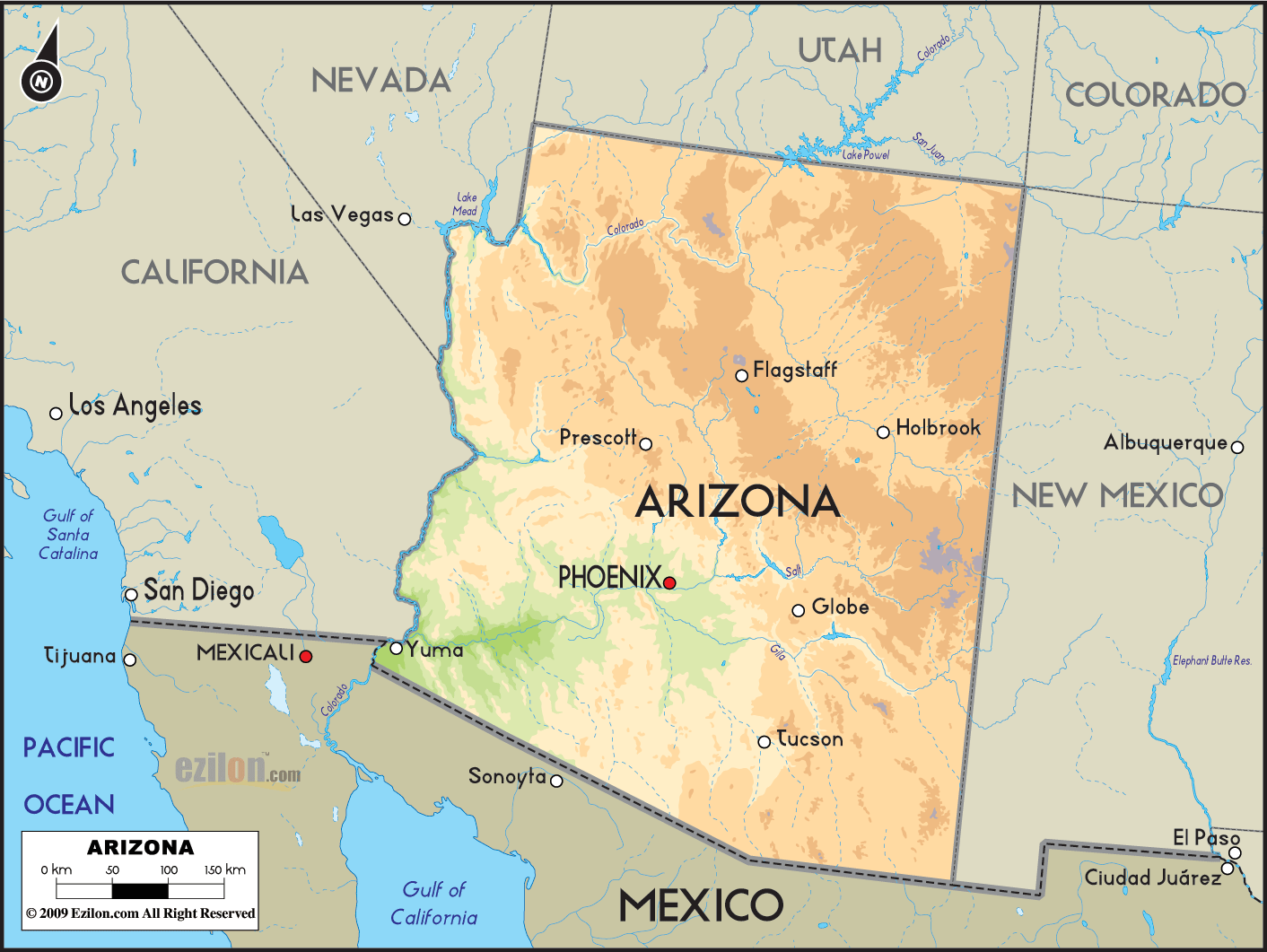
Description: The Geographical map of Arizona deserts such as Sonoran, Mojave, and Chihuahuan zones.
 Most people picture Arizona as endless sand with towering cactus. The truth is richer. Arizona holds three distinct deserts plus a necklace of arid basins and sky-island mountains that break up the dryness with pockets of forest and springs. Use the map as your guide while you read. I will point to the places your eyes should land so you can match each description to a real location.
Arizona’s arid country forms a north-to-south gradient shaped by two ideas you can see on the map:
Basin and Range covers the south and west. Think long flat valleys in pale colors, split by isolated ranges in tan.
The Colorado Plateau in the north is higher, cooler, and drier in winter, with big mesas and canyons.
Within that framework, Arizona hosts three deserts:
Sonoran Desert – the most significant piece, wrapping Yuma, Phoenix, and Tucson.
Mojave Desert – the northwest corner around Lake Mead, Lake Mohave, Lake Havasu, Kingman, and the lower Grand Canyon region.
Chihuahuan Desert – a small wedge in the far southeast near Douglas and the San Bernardino Valley.
Two river systems outline the drylands right on the map: the Colorado River along the western border and the Gila–Salt–Verde network across the south and center.
Where to look: Broad greenish basins from Yuma east to Gila Bend, north through Phoenix, and southeast through Tucson and Nogales. Mountains like the Kofa, Superstition, Catalina, and Santa Rita ranges rise as tan “islands” from the flats.
Climate pattern: The Sonoran is famous for two rainy seasons—light Pacific storms in winter and the summer monsoon in July to September. Temperatures run very hot at low elevations around Yuma and the lower Colorado corridor, moderating with altitude toward Phoenix and Tucson.
Subregions you can read from the map
Lower Colorado River Valley Sonoran – the hottest, driest belt along the Colorado River from Yuma to Parker. Pale, smooth valley floors show active dunes and broad washes.
Arizona Upland Sonoran – higher, rockier terrain between Phoenix and Tucson, with foothills and bajadas spilling from the surrounding ranges.
Plants and wildlife to expect: Iconic saguaro cactus dominates slopes in the Arizona Upland. Palo verde, ironwood, mesquite, ocotillo, cholla, and prickly pear fill washes and fans. Wildlife includes Gila monster, desert tortoise, cactus wren, Gambel’s quail, javelina, and bighorn sheep in the steeper hills. Along canals and the Salt or Gila rivers look for cottonwoods, willows, and wintering waterfowl.
Human imprint is evident on the map. The dense road web and river lines around Phoenix and Yuma reflect irrigation and settlement. Yuma is a winter-vegetable capital fed by Colorado River water. Phoenix grew along the ancient Hohokam canal pattern, later rebuilt as the Salt River Project.
Not-to-miss Sonoran places
Saguaro National Park near Tucson for classic giant cactus landscapes.
Organ Pipe Cactus National Monument near Sonoyta for organ pipe and pristine bajadas.
Kofa National Wildlife Refuge north of Yuma for rugged volcanic peaks and desert bighorn.
Sonoran Desert National Monument and the Superstition Mountains east of Phoenix for Arizona Upland hikes.
Where to look: The northwest triangle around Lake Mead, Hoover Dam, Lake Mohave, Laughlin/Bullhead City, Kingman, Lake Havasu City, and the Hualapai and Detrital valleys.
Climate pattern: Cooler winters and a stronger winter-rain emphasis than the Sonoran. Elevations are higher on average, so summer heat is fierce, but nights can be cooler.
Signature clues The map shows steep, narrow canyons where the Colorado squeezes into reservoirs, and higher benches above the basins. These benches host Joshua trees and blackbush. On the fans, you still see creosote and bursage, but the overall look is more open and gray-green than the Sonoran’s yellow-green palette.
Travel ideas you can design from the map
Trace the river-lakes chain from Lake Mead to Lake Havasu for boating, fishing, and canyon geology.
Base in Kingman and explore Oatman, the Black Mountains, and viewpoints along the lower Grand Canyon margins.
Conservation notes: Much of the shoreline falls within Lake Mead National Recreation Area, where desert tortoise habitat overlaps with recreation zones. Watch for designated routes and seasonal closures.
Where to look: The far southeast around Douglas, Bisbee, and the San Bernardino and San Simon valleys near the New Mexico border. The Peloncillo and Chiricahua ranges line the edges.
Climate pattern: Summer monsoon dominates rainfall. Winters are cool with occasional snow at higher elevations. Valley floors are slightly higher than much of the Sonoran, and this added elevation shapes vegetation.
Plants and wildlife: Expect lechuguilla, sotol, ocotillo, tarbush, and grasses. Saguaros become scarce. The desert merges quickly into grassland and oak savanna around the Chiricahua and Huachuca foothills. The nearby San Pedro River forms a green wildlife corridor famous for migratory birds like vermilion flycatchers and, in the canyons, the elegant trogon.
Field loop: Follow the map from Tucson to Benson, then Bisbee and Douglas. Cut east to Portal for the Chiricahua canyons and north to Willcox across the Sulphur Springs Valley. You will cross the desert, the grassland, and the sky-island forest in one day.
Scattered tan knots south and east of Phoenix are isolated ranges including the Catalinas, Rincons, Santa Ritas, Baboquivaris, Huachucas, and Chiricahuas. These sky islands lift moisture and create stacked life zones: desert scrub at the foot, oak and juniper on middle slopes, pine and fir near the top. On the map, they look like compact mountains ringed by pale basins. On the ground, they offer more extraordinary summer escapes, unique species, and spectacular views across the drylands.
Colorado River – the blue boundary from Lake Powell to Yuma. Vast reservoirs and narrow canyon links mark gradients in rock hardness and erosion.
Gila River – the main desert trunk from Safford through Phoenix to Yuma.
Salt and Verde Rivers – feed the Phoenix basin. Where the map shows lakes like Roosevelt, canyons tighten, and dams exploit narrow bedrock.
Santa Cruz and San Pedro Rivers – slender ribbons through southern basins that support cottonwood galleries, riparian birds, and archaeology sites.
Alluvial fans and bajadas are seen as gentle slopes at the base of every desert range. Trails and two-tracks typically zigzag these fans to reach canyons.
Playas and dunes – flat, often light colored basin centers and the sand seas west of Yuma.
Winter to early spring – prime time for lower Sonoran hikes near Phoenix, Yuma, and Organ Pipe.
March to April – wildflower displays during good rain years, plus saguaro bloom later in spring.
Late summer – monsoon green-up in the Chihuahuan wedge and the sky islands. Afternoon storms are common; start early.
Fall – clear air and mild temperatures in the Mojave around the river lakes.
Distances are large and services are sparse in the Mojave and the far southeast. Carry extra water, a paper map backup, and let someone know your route.
Bridge crossings of the Colorado are limited. Plan your crossing at Hoover Dam area, Laughlin/Bullhead, Parker, or Yuma.
Respect tribal lands and border areas where access may be restricted.
Pack in and pack out. Cryptobiotic soils and fragile cactus take decades to recover.
In summer, hike at dawn, rest midday, and watch storm cells that can trigger flash floods in washes.
Where do I see saguaros? Around Tucson and the foothills ringing Phoenix, especially Saguaro National Park and Usery Mountain or South Mountain areas.
Where do I see Joshua trees? Northwest around Kingman, Hualapai Valley, and benches above Lake Mead and Lake Mohave.
Where can I find an organ pipe cactus? Organ Pipe Cactus National Monument near Sonoyta and Lukeville.
Where can I bird in a riparian desert? San Pedro Riparian corridor near Sierra Vista, Santa Cruz near Tucson, and Gila backwaters around Yuma.
Best one-day sampler? Phoenix to Superstition Foothills and Roosevelt Lake for Arizona Upland, or Tucson to Saguaro NP and Mount Lemmon for a complete desert-to-pine journey.
Arizona is not one desert. It is a mosaic of Sonoran, Mojave, and Chihuahuan zones stitched together by the Colorado, Gila, Salt, Verde, Santa Cruz, and San Pedro rivers and punctuated by sky-island mountains. When you read the map with these lenses, cactus country sorts itself into distinct, easy-to-understand regions that you can explore with purpose and care.

Counties and Road Map of Arizona
Counties and Road map and map image of Arizona.

Physical Map of Arizona
Physical map and map image of Arizona.

Regional Directory of United States of America
Information and guide about United States of America and websites with American topics.

Regional Directory of Europe
Information and guide about Europe and websites with European topics.

Regional Directory of Australia
Information and guide about Australia and websites with Australian topics.